
Ikeja topographic map
Interactive map
Click on the map to display elevation.
About this map
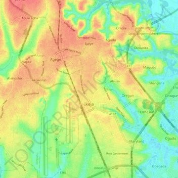
Name: Ikeja topographic map, elevation, terrain.
Location: Ikeja, Lagos State, Nigeria (6.55095 3.31012 6.65876 3.38319)
Average elevation: 95 ft
Minimum elevation: -3 ft
Maximum elevation: 187 ft
Other topographic maps
Click on a map to view its topography, its elevation and its terrain.
Tincan Island
Nigeria > Lagos State > Apapa
Tincan Island, Apapa, Lagos State, Nigeria
Average elevation: 10 ft
Makoko
Nigeria > Lagos State > Lagos Mainland
Makoko, Lagos Mainland, Lagos State, Nigeria
Average elevation: 10 ft
Ikate
Nigeria > Lagos State > Eti Osa
Ikate, Eti Osa, Lagos State, 105102, Nigeria
Average elevation: 10 ft
Oshodi/Isolo
Nigeria > Lagos State > Oshodi/Isolo
Oshodi/Isolo, Lagos State, 100263, Nigeria
Average elevation: 56 ft
Igbo
Nigeria > Lagos State > Eti Osa
Igbo, Eti Osa, Lagos State, 500001, Nigeria
Average elevation: 16 ft
Lagos
Nigeria > Lagos State > Lagos Island
Lagos, Lagos Island, Lagos State, 100242, Nigeria
Average elevation: 16 ft
Lekki
Nigeria > Lagos State > Ibeju Lekki
Lekki, Ibeju Lekki, Lagos State, Nigeria
Average elevation: 7 ft