
Make a donation
Gear up for your next adventure:
As an Amazon Associate, this site earns from qualifying purchases at no extra cost to you.
Riemerling topographic map
Click on the map to display elevation.
Make a donation
Gear up for your next adventure:
As an Amazon Associate, this site earns from qualifying purchases at no extra cost to you.
About this map
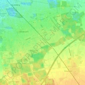
Name: Riemerling topographic map, elevation, terrain.
Average elevation: 1,847 ft
Minimum elevation: 1,788 ft
Maximum elevation: 1,890 ft
Make a donation
Gear up for your next adventure:
As an Amazon Associate, this site earns from qualifying purchases at no extra cost to you.
Other topographic maps
Click on a map to view its topography, its elevation and its terrain.
Neubiberg
Deutschland > Bayern > Landkreis München
Das Gebiet der unmittelbar an München angrenzenden Gemeinde ist ungewöhnlich langgestreckt, bei einer West-Ost-Ausdehnung von etwa 6 km ist es nur zwischen 0,5 und 1,5 km breit. Das flache Gemeindegebiet ist im Westen 547 m hoch und steigt nach Osten auf rund 555 m Seehöhe an, was freilich für den Besucher…
Average elevation: 1,811 ft
Ottobrunn
Deutschland > Bayern > Landkreis München
Die nächstgelegenen Wälder – der Höhenkirchener Forst, der Perlacher Forst, der Hofoldinger Forst und der Grünwalder Forst – befinden sich allesamt in einem Umkreis von höchstens zehn Kilometern. Unter den Naherholungsgebieten Oberbayerns sind der Starnberger See und der Tegernsee keine 40, der…
Average elevation: 1,834 ft
Unterföhring
Deutschland > Bayern > Landkreis München
Dank der vielen Unternehmen ist die Gemeinde schuldenfrei und hat sogar Rücklagen in Höhe von 442 Millionen Euro gebildet (Stand: Dezember 2017), was über 35.000 Euro/Einwohner entspricht und u. a. das Anbieten einer kostenlosen Kinderbetreuung ermöglicht.
Average elevation: 1,644 ft
Aying
Deutschland > Bayern > Landkreis München
Aying wird von sechs Gemeinden Brunnthal, Egmating (Kreis Ebersberg), Feldkirchen-Westerham (Kreis Rosenheim), Glonn (Kreis Ebersberg), Höhenkirchen-Siegertsbrunn und Valley (Kreis Miesbach) umgeben.
Average elevation: 2,037 ft
Make a donation
Gear up for your next adventure:
As an Amazon Associate, this site earns from qualifying purchases at no extra cost to you.
Baierbrunn
Deutschland > Bayern > Landkreis München
Auf der Flur Konradshöhe am südöstlichen Ortsrand über der Isar befand sich die abgegangene Burg Baierbrunn.
Average elevation: 2,044 ft
Garching bei München
Deutschland > Bayern > Landkreis München
Aschheim | Aying | Baierbrunn | Brunnthal | Feldkirchen | Gräfelfing | Grasbrunn | Grünwald | Haar | Hohenbrunn | Höhenkirchen-Siegertsbrunn | Ismaning | Kirchheim bei München | Neubiberg | Neuried | Oberhaching | Oberschleißheim | Ottobrunn | Planegg | Pullach im Isartal | Putzbrunn | Sauerlach |…
Average elevation: 1,585 ft
Unterschleißheim
Deutschland > Bayern > Landkreis München
Aschheim | Aying | Baierbrunn | Brunnthal | Feldkirchen | Gräfelfing | Grasbrunn | Grünwald | Haar | Hohenbrunn | Höhenkirchen-Siegertsbrunn | Ismaning | Kirchheim bei München | Neubiberg | Neuried | Oberhaching | Oberschleißheim | Ottobrunn | Planegg | Pullach im Isartal | Putzbrunn | Sauerlach |…
Average elevation: 1,558 ft
Oberhaching
Deutschland > Bayern > Landkreis München
Zusätzlich bietet sich am Kyberg, einem ins Gleißental hineinragenden Höhenrücken, ein weiter Blick in die Ebene. Hier finden sich Reste einer steinzeitlichen Besiedelung, und hier wird auch der Fürstensitz aus bajuwarischer Zeit vermutet. Heute steht hier das Rathaus.
Average elevation: 1,991 ft
Make a donation
Gear up for your next adventure:
As an Amazon Associate, this site earns from qualifying purchases at no extra cost to you.
Taufkirchen
Deutschland > Bayern > Landkreis München
In der Zeit von Hilprant gab es in Taufkirchen eine Schranne, ein dörflicher Gerichtsplatz ohne eigene Rechtsprechung. Dort sprach ein Richter von Wolfratshausen Recht. Hilprants Sohn Gebhard war Abt des Klosters Tegernsee. Auch das Kloster Ebersberg wurde angeblich um 1343 von einem Taufkircher geleitet. Der…
Average elevation: 1,903 ft
Gräfelfing
Deutschland > Bayern > Landkreis München
Aschheim | Aying | Baierbrunn | Brunnthal | Feldkirchen | Gräfelfing | Grasbrunn | Grünwald | Haar | Hohenbrunn | Höhenkirchen-Siegertsbrunn | Ismaning | Kirchheim bei München | Neubiberg | Neuried | Oberhaching | Oberschleißheim | Ottobrunn | Planegg | Pullach im Isartal | Putzbrunn | Sauerlach |…
Average elevation: 1,781 ft
Schäftlarn
Deutschland > Bayern > Landkreis München
Aschheim | Aying | Baierbrunn | Brunnthal | Feldkirchen | Gräfelfing | Grasbrunn | Grünwald | Haar | Hohenbrunn | Höhenkirchen-Siegertsbrunn | Ismaning | Kirchheim bei München | Neubiberg | Neuried | Oberhaching | Oberschleißheim | Ottobrunn | Planegg | Pullach im Isartal | Putzbrunn | Sauerlach |…
Average elevation: 2,103 ft
Unterhaching
Deutschland > Bayern > Landkreis München
Die Familie W. (so schrieb im Januar 1936 der Bürgermeister u. A. unter dem Betreff >Unfruchtbarmachung< an das Gesundheitsamt) hat in der Familie schwere Krankheiten aufzuweisen, die den Verdacht rechtfertigen, dass es sich um erbliche Krankheiten handelt. Eine 26-jährige Tochter ist vollkommen…
Average elevation: 1,824 ft
Make a donation
Gear up for your next adventure:
As an Amazon Associate, this site earns from qualifying purchases at no extra cost to you.
Grünwald
Deutschland > Bayern > Landkreis München
Mit einem Gewerbesteuerhebesatz von 240 % zählt die Gemeinde zu den steuerlich attraktivsten Standorten Deutschlands. Der Vorort Grünwald ist steuerlich deutlich günstiger als die bayerische Landeshauptstadt München (Gewerbesteuerhebesatz 490 %). Im Jahr 2012 erzielte Grünwald Einnahmen aus der…
Average elevation: 1,932 ft
Putzbrunn
Deutschland > Bayern > Landkreis München
Aschheim | Aying | Baierbrunn | Brunnthal | Feldkirchen | Gräfelfing | Grasbrunn | Grünwald | Haar | Hohenbrunn | Höhenkirchen-Siegertsbrunn | Ismaning | Kirchheim bei München | Neubiberg | Neuried | Oberhaching | Oberschleißheim | Ottobrunn | Planegg | Pullach im Isartal | Putzbrunn | Sauerlach |…
Average elevation: 1,811 ft
85716
Deutschland > Bayern > Landkreis München > Unterschleißheim > Riedmoos
Average elevation: 1,555 ft
Make a donation
Gear up for your next adventure:
As an Amazon Associate, this site earns from qualifying purchases at no extra cost to you.
Ismaning
Deutschland > Bayern > Landkreis München
Aschheim | Aying | Baierbrunn | Brunnthal | Feldkirchen | Gräfelfing | Grasbrunn | Grünwald | Hohenbrunn | Höhenkirchen-Siegertsbrunn | Ismaning | Kirchheim bei München | Neubiberg | Neuried | Oberhaching | Oberschleißheim | Ottobrunn | Planegg | Pullach im Isartal | Putzbrunn | Sauerlach | Schäftlarn |…
Average elevation: 1,591 ft
Make a donation
Gear up for your next adventure:
As an Amazon Associate, this site earns from qualifying purchases at no extra cost to you.
Pullach im Isartal
Deutschland > Bayern > Landkreis München
Der Isarkanal wird im Sommer von Flößen befahren. Am Wasserkraftwerk Pullach rutschen die Flöße auf einer Floßrutsche mit 11 m Höhenunterschied herunter. Zu besichtigen am besten am Wochenende im Sommer etwa zwischen 14 und 17 Uhr.
Average elevation: 1,896 ft
Sauerlach
Deutschland > Bayern > Landkreis München
Das Gelände der Gemeinde steigt von Nordosten nach Südwesten zunächst gering, dann stärker an. Der Höhenunterschied im Gemeindegebiet beträgt etwa 100 Meter. Im Buchetholz, am südwestlichen Rand der Gemeinde, südlich von Gumpertsham, befindet sich mit knapp 700 Metern die höchste Erhebung. Der tiefste…
Average elevation: 2,083 ft
Straßlach-Dingharting
Deutschland > Bayern > Landkreis München
Aschheim | Aying | Baierbrunn | Brunnthal | Feldkirchen | Gräfelfing | Grasbrunn | Grünwald | Haar | Hohenbrunn | Höhenkirchen-Siegertsbrunn | Ismaning | Kirchheim bei München | Neubiberg | Neuried | Oberhaching | Oberschleißheim | Ottobrunn | Planegg | Pullach im Isartal | Putzbrunn | Sauerlach |…
Average elevation: 2,080 ft
Make a donation
Gear up for your next adventure:
As an Amazon Associate, this site earns from qualifying purchases at no extra cost to you.
Grasbrunn
Deutschland > Bayern > Landkreis München
Aschheim | Aying | Baierbrunn | Brunnthal | Feldkirchen | Gräfelfing | Grasbrunn | Grünwald | Haar | Hohenbrunn | Höhenkirchen-Siegertsbrunn | Ismaning | Kirchheim bei München | Neubiberg | Neuried | Oberhaching | Oberschleißheim | Ottobrunn | Planegg | Pullach im Isartal | Putzbrunn | Sauerlach |…
Average elevation: 1,834 ft
Make a donation
Gear up for your next adventure:
As an Amazon Associate, this site earns from qualifying purchases at no extra cost to you.
85635
Deutschland > Bayern > Landkreis München > Höhenkirchen-Siegertsbrunn
Average elevation: 1,929 ft
85551
Deutschland > Bayern > Landkreis München > Kirchheim bei München > Kreuzhauserhof
Average elevation: 1,663 ft
Make a donation
Gear up for your next adventure:
As an Amazon Associate, this site earns from qualifying purchases at no extra cost to you.
Brunnthal
Deutschland > Bayern > Landkreis München
Die katholische Pfarrei Brunnthal wurde aus den bisherigen Kuratien Brunnthal und Hofolding-Faistenhaar gebildet. Katholische Kirchen und Kapellen stehen in Brunnthal (Sankt Nikolaus), Hofolding (Heilig Kreuz und Marienkapelle), Faistenhaar (Sankt Peter und Paul) und Kirchstockach (Sankt Georg). Seit der…
Average elevation: 1,991 ft
Make a donation
Gear up for your next adventure:
As an Amazon Associate, this site earns from qualifying purchases at no extra cost to you.
Hohenbrunn
Deutschland > Bayern > Landkreis München
Die Gemeinde liegt im Südosten Münchens, in der Nähe des Autobahnkreuzes München-Süd. Es besteht eine S-Bahn-Verbindung nach München (S5, Bahnstrecke München-Giesing–Kreuzstraße). Der Ort Hohenbrunn ist vom Münchener Zentrum etwa 14 km entfernt und allseitig von Wäldern umgeben. Der nordwestlich…
Average elevation: 1,867 ft
Grünwalder Forst
Deutschland > Bayern > Landkreis München
Aschheim | Aying | Baierbrunn | Brunnthal | Feldkirchen | Gräfelfing | Grasbrunn | Grünwald | Hohenbrunn | Höhenkirchen-Siegertsbrunn | Ismaning | Kirchheim bei München | Neubiberg | Neuried | Oberhaching | Oberschleißheim | Ottobrunn | Planegg | Pullach im Isartal | Putzbrunn | Sauerlach | Schäftlarn |…
Average elevation: 1,955 ft
Make a donation
Gear up for your next adventure:
As an Amazon Associate, this site earns from qualifying purchases at no extra cost to you.
Oberschleißheim
Deutschland > Bayern > Landkreis München
Aschheim | Aying | Baierbrunn | Brunnthal | Feldkirchen | Gräfelfing | Grasbrunn | Grünwald | Hohenbrunn | Höhenkirchen-Siegertsbrunn | Ismaning | Kirchheim bei München | Neubiberg | Neuried | Oberhaching | Oberschleißheim | Ottobrunn | Planegg | Pullach im Isartal | Putzbrunn | Sauerlach | Schäftlarn |…
Average elevation: 1,588 ft
Planegg
Deutschland > Bayern > Landkreis München
Im März 2016 beschloss die Gemeinde den Entwurf der Architekten Molenaar/Weber, der einen größeren Bahnhofsvorplatz, umgeben von Geschäften und einem Supermarkt, vorsah. Auf Höhe der Gleise sollte ein Fahrradschnellweg und ein zweistöckiges Bike-and-Ride-Haus entstehen. In der Folge wurde das Grundstück…
Average elevation: 1,831 ft
Feldkirchen
Deutschland > Bayern > Landkreis München
Aschheim | Aying | Baierbrunn | Brunnthal | Feldkirchen | Gräfelfing | Grasbrunn | Grünwald | Haar | Hohenbrunn | Höhenkirchen-Siegertsbrunn | Ismaning | Kirchheim bei München | Neubiberg | Neuried | Oberhaching | Oberschleißheim | Ottobrunn | Planegg | Pullach im Isartal | Putzbrunn | Sauerlach |…
Average elevation: 1,722 ft
Make a donation
Gear up for your next adventure:
As an Amazon Associate, this site earns from qualifying purchases at no extra cost to you.
Neuried
Deutschland > Bayern > Landkreis München
Das von dem Münchner Architekten Andreas Meck geplante katholische Pfarrzentrum St. Nikolaus wurde 2008 der Gemeinde übergeben. Rudolf Bott gestaltete die aus Beton gegossene Altarinsel. Ein von Andreas Meck konzipiertes sphärisches Kreuz, dessen Höhe und Breite 15 Meter beträgt, wurde 2009 vor dem…
Average elevation: 1,870 ft
Baierbrunn
Deutschland > Bayern > Landkreis München
Auf der Flur Konradshöhe am südöstlichen Ortsrand über der Isar befand sich die abgegangene Burg Baierbrunn.
Average elevation: 2,044 ft
Neubiberg
Deutschland > Bayern > Landkreis München
Neubiberg grenzt an die Bezirksteile Waldperlach, Neuperlach, und Altperlach des Münchner Stadtbezirks 16 Ramersdorf-Perlach sowie an den Bezirksteil Südgiesing des Stadtbezirks 17 Obergiesing (Obergiesing-Fasangarten) sowie an die Gemeinden Ottobrunn, Unterhaching und an den Gemeindeteil Waldkolonie der…
Average elevation: 1,811 ft
Make a donation
Gear up for your next adventure:
As an Amazon Associate, this site earns from qualifying purchases at no extra cost to you.
Straßlach-Dingharting
Deutschland > Bayern > Landkreis München
Beigarten | Deigstetten | Ebertshausen | Epolding | Frundsbergerhöhe | Gleißentalweiher | Großdingharting | Hailafing | Holzhausen | Kirchlberg | Kleindingharting | Mühlthal | Straßlach
Average elevation: 2,080 ft
Unterschleißheim
Deutschland > Bayern > Landkreis München
Aschheim | Aying | Baierbrunn | Brunnthal | Feldkirchen | Gräfelfing | Grasbrunn | Grünwald | Hohenbrunn | Höhenkirchen-Siegertsbrunn | Ismaning | Kirchheim bei München | Neubiberg | Neuried | Oberhaching | Oberschleißheim | Ottobrunn | Planegg | Pullach im Isartal | Putzbrunn | Sauerlach | Schäftlarn |…
Average elevation: 1,558 ft
Taufkirchen
Deutschland > Bayern > Landkreis München
In der Zeit von Hilprant gab es in Taufkirchen eine Schranne, einen dörflichen Gerichtsplatz ohne eigene Rechtsprechung. Dort sprach ein Richter von Wolfratshausen Recht. Hilprants Sohn Gebhard war Abt des Klosters Tegernsee. Auch das Kloster Ebersberg wurde angeblich um 1343 von einem Taufkircher geleitet.…
Average elevation: 1,903 ft