
Make a donation
Gear up for your next adventure:
As an Amazon Associate, this site earns from qualifying purchases at no extra cost to you.
Lake Maracaibo topographic map
Click on the map to display elevation.
Make a donation
Gear up for your next adventure:
As an Amazon Associate, this site earns from qualifying purchases at no extra cost to you.
About this map
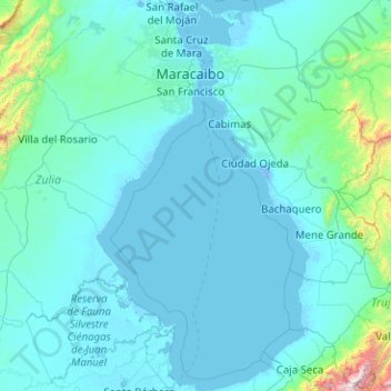
Name: Lake Maracaibo topographic map, elevation, terrain.
Location: Lake Maracaibo, Venezuela (9.03068 -72.12761 11.01939 -71.02587)
Average elevation: 492 ft
Minimum elevation: -23 ft
Maximum elevation: 12,569 ft
Make a donation
Gear up for your next adventure:
As an Amazon Associate, this site earns from qualifying purchases at no extra cost to you.
Other topographic maps
Click on a map to view its topography, its elevation and its terrain.
Make a donation
Gear up for your next adventure:
As an Amazon Associate, this site earns from qualifying purchases at no extra cost to you.
Cueva del Guácharo
Venezuela > Monagas State > Municipio Caripe > La Laguna > Corral Viejo
Average elevation: 4,327 ft
Make a donation
Gear up for your next adventure:
As an Amazon Associate, this site earns from qualifying purchases at no extra cost to you.
Make a donation
Gear up for your next adventure:
As an Amazon Associate, this site earns from qualifying purchases at no extra cost to you.
Valencia
Venezuela > Carabobo State > Municipio Valencia
The elevation of the city is 520 metres (1,710 feet).
Average elevation: 1,752 ft
Guiana Highlands
Venezuela > Bolivar State > Municipio Angostura
The Guiana Shield (French: Plateau des Guyanes, Bouclier guyanais; Dutch: Hoogland van Guyana, Guianaschild; Portuguese: Planalto das Guianas, Escudo das Guianas; Spanish: Escudo guayanés) is one of the three cratons of the South American Plate. It is a 1.7 billion-year-old Precambrian geological formation in…
Average elevation: 1,719 ft
Mérida
Venezuela > Merida State > Municipio Libertador
This city sits on a plateau nestled in the valley of the Chama River, which runs from end to end. The town of Mérida is located at an altitude of 1,600 metres (5,200 feet). As background on the horizon rises the country's highest summit: the Pico Bolívar with an altitude of 4,981 metres (16,342 feet).
Average elevation: 8,727 ft
Make a donation
Gear up for your next adventure:
As an Amazon Associate, this site earns from qualifying purchases at no extra cost to you.
Make a donation
Gear up for your next adventure:
As an Amazon Associate, this site earns from qualifying purchases at no extra cost to you.
Cerro Sarisariñama
Venezuela > Bolivar State > Municipio Sucre
Cerro Sarisariñama is a tepui, a flat-topped mountain in Jaua-Sarisariñama National Park at the far south-west of Bolívar State, Venezuela, near the border with Brazil. Its altitude range is between 300 m (980 ft) and 2,350 m (7,710 ft). The name of the mountain originates from the tale of the local…
Average elevation: 4,255 ft
Make a donation
Gear up for your next adventure:
As an Amazon Associate, this site earns from qualifying purchases at no extra cost to you.
San Fernando de Apure
Venezuela > Apure State > Municipio San Fernando
The relief of San Fernando is totally a plain. Natural land elevations do not exist, and the visibility of the horizon can reach up to 10 km. Some high barriers can be artificially by engineer installations for the prevention of floods. The city is established on humid grounds, and for this reason civil…
Average elevation: 148 ft
Make a donation
Gear up for your next adventure:
As an Amazon Associate, this site earns from qualifying purchases at no extra cost to you.
Make a donation
Gear up for your next adventure:
As an Amazon Associate, this site earns from qualifying purchases at no extra cost to you.
Mérida
Venezuela > Merida State > Municipio Libertador
This city sits on a plateau nestled in the valley of the Chama River, which runs from end to end. The town of Mérida is located at an altitude of 1,600 metres (5,200 feet). As background on the horizon rises the country's highest summit: the Pico Bolívar with an altitude of 4,981 metres (16,342 feet).
Average elevation: 8,727 ft
Make a donation
Gear up for your next adventure:
As an Amazon Associate, this site earns from qualifying purchases at no extra cost to you.
Make a donation
Gear up for your next adventure:
As an Amazon Associate, this site earns from qualifying purchases at no extra cost to you.
Make a donation
Gear up for your next adventure:
As an Amazon Associate, this site earns from qualifying purchases at no extra cost to you.
Make a donation
Gear up for your next adventure:
As an Amazon Associate, this site earns from qualifying purchases at no extra cost to you.
Punta Esmeralda
Venezuela > Nueva Esparta State > Municipio Maneiro > Pampatar
Average elevation: 20 ft
Make a donation
Gear up for your next adventure:
As an Amazon Associate, this site earns from qualifying purchases at no extra cost to you.
Make a donation
Gear up for your next adventure:
As an Amazon Associate, this site earns from qualifying purchases at no extra cost to you.
Make a donation
Gear up for your next adventure:
As an Amazon Associate, this site earns from qualifying purchases at no extra cost to you.
Make a donation
Gear up for your next adventure:
As an Amazon Associate, this site earns from qualifying purchases at no extra cost to you.
Make a donation
Gear up for your next adventure:
As an Amazon Associate, this site earns from qualifying purchases at no extra cost to you.
Mérida
Venezuela > Merida State > Municipio Libertador
This city sits on a plateau nestled in the valley of the Chama River, which runs from end to end. The town of Mérida is located at an altitude of 1,600 metres (5,200 feet). As background on the horizon rises the country's highest summit: the Pico Bolívar with an altitude of 4,981 metres (16,342 feet).
Average elevation: 8,727 ft
Make a donation
Gear up for your next adventure:
As an Amazon Associate, this site earns from qualifying purchases at no extra cost to you.
Santa Rosa Sur
Venezuela > Portuguesa State > Municipio José Vicente de Unda
Average elevation: 3,737 ft
Make a donation
Gear up for your next adventure:
As an Amazon Associate, this site earns from qualifying purchases at no extra cost to you.
Make a donation
Gear up for your next adventure:
As an Amazon Associate, this site earns from qualifying purchases at no extra cost to you.
Make a donation
Gear up for your next adventure:
As an Amazon Associate, this site earns from qualifying purchases at no extra cost to you.
Mérida
Venezuela > Merida State > Municipio Libertador
This city sits on a plateau nestled in the valley of the Chama River, which runs from end to end. The town of Mérida is located at an altitude of 1,600 metres (5,200 feet). As background on the horizon rises the country's highest summit: the Pico Bolívar with an altitude of 4,981 metres (16,342 feet).
Average elevation: 8,727 ft
Make a donation
Gear up for your next adventure:
As an Amazon Associate, this site earns from qualifying purchases at no extra cost to you.
Make a donation
Gear up for your next adventure:
As an Amazon Associate, this site earns from qualifying purchases at no extra cost to you.
San Fernando de Apure
Venezuela > Apure State > Municipio San Fernando
The relief of San Fernando is totally a plain. Natural land elevations do not exist, and the visibility of the horizon can reach up to 10 km. Some high barriers can be artificially by engineer installations for the prevention of floods. The city is established on humid grounds, and for this reason civil…
Average elevation: 148 ft
Make a donation
Gear up for your next adventure:
As an Amazon Associate, this site earns from qualifying purchases at no extra cost to you.
Cerro Colorado
Venezuela > Miranda State > Municipio Zamora > Parroquia Guatire
Average elevation: 1,991 ft
Cerro Delgado Chalbaud
Venezuela > Amazonas State > Municipio Autónomo Alto Orinoco
Average elevation: 3,058 ft
Make a donation
Gear up for your next adventure:
As an Amazon Associate, this site earns from qualifying purchases at no extra cost to you.