
The Falls at Imperial Oaks topographic map
Interactive map
Click on the map to display elevation.
About this map
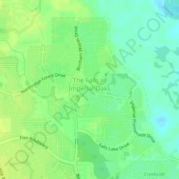
Name: The Falls at Imperial Oaks topographic map, elevation, terrain.
Location: The Falls at Imperial Oaks, Montgomery County, Texas, USA (30.13291 -95.39517 30.15468 -95.36799)
Average elevation: 105 ft
Minimum elevation: 75 ft
Maximum elevation: 121 ft
Other topographic maps
Click on a map to view its topography, its elevation and its terrain.
Palo Duro Canyon State Park
Palo Duro Canyon State Park, Randall County, Texas, USA
Average elevation: 3,215 ft
Lake Houston
Lake Houston, Pine Cone Drive, Sherwood Trails, Houston, Harris County, Texas, 77339, USA
Average elevation: 66 ft
Lake Corpus Christi
Lake Corpus Christi, Lookout Drive, Lagarto, Live Oak County, Texas, USA
Average elevation: 174 ft
Point Loma
USA > Texas > Point Loma
Point Loma, San Patricio County, Texas, 78368, USA
Average elevation: 112 ft
High Island
USA > Texas > High Island
High Island, Galveston County, Texas, 77623, USA
Average elevation: 10 ft
Joe Pool Lake
USA > Texas > Cedar Hill
Joe Pool Lake, Lake Ridge Parkway, Cedar Hill, Dallas County, Texas, 75054, USA
Average elevation: 587 ft
Brushy Creek
USA > Texas > Round Rock
Brushy Creek, Round Rock, Williamson County, Texas, 78680, USA
Average elevation: 774 ft
Olmos Basin Park
USA > Texas > San Antonio
Olmos Basin Park, San Antonio, Bexar County, Texas, USA
Average elevation: 745 ft
Whitesboro
USA > Texas > Whitesboro
Whitesboro, Grayson County, Texas, 76273, USA
Average elevation: 768 ft
Leon Creek
USA > Texas > San Antonio
Leon Creek, San Antonio, Bexar County, Texas, 78257, USA
Average elevation: 1,145 ft
Friedrich Wilderness Park
USA > Texas > San Antonio
Friedrich Wilderness Park, San Antonio, Bexar County, Texas, USA
Average elevation: 1,263 ft
Cochran's Crossing
USA > Texas > The Woodlands
Cochran's Crossing, The Woodlands, Montgomery County, Texas, 77381, USA
Average elevation: 164 ft
Devil's River State Natural Area
Devil's River State Natural Area, Dolan Creek Road, Val Verde County, Texas, USA
Average elevation: 1,752 ft
Nueces River
USA > Texas > Corpus Christi
Nueces River, Corpus Christi, Nueces County, Texas, 78410, USA
Average elevation: 16 ft
Stephenson Nature Preserve And Outdoor Education Center
Stephenson Nature Preserve And Outdoor Education Center, West William Cannon Drive, Whispering Oaks, Austin, Travis County, Texas, 78749, USA
Average elevation: 755 ft
Balcones District Park
Balcones District Park, 12017, North Loop Business Park, Austin, Travis County, Texas, 78759, USA
Average elevation: 771 ft
Baytown Nature Center
Baytown Nature Center, Ridgeway Avenue, Baytown, Harris County, Texas, USA
Average elevation: 7 ft
Brazos Bend State Park
Brazos Bend State Park, Fort Bend County, Texas, USA
Average elevation: 56 ft
Heard Natural Science Museum & Wildlife Sanctuary
Heard Natural Science Museum & Wildlife Sanctuary, Wood Duck Trail, McKinney, Collin County, Texas, 75609, USA
Average elevation: 587 ft
Rummel Creek
Rummel Creek, Houston, Harris County, Texas, TX 77043, USA
Average elevation: 92 ft
Alligator Alley
Alligator Alley, Houston, Harris County, Texas, 773345, USA
Average elevation: 66 ft
River Walk
USA > Texas > San Antonio
River Walk, La Villita, San Antonio, Bexar County, Texas, USA
Average elevation: 663 ft
Armand Bayou Nature Center
Armand Bayou Nature Center, Prairie Interpretive Trail, Pasadena, Harris County, Texas, 77507, USA
Average elevation: 16 ft
Jollyville Plateau
Jollyville Plateau, Austin, Travis County, Texas, 78726, USA
Average elevation: 974 ft
San Jacinto River;Houston Ship Channel
San Jacinto River;Houston Ship Channel, Harris County, Texas, USA
Average elevation: 16 ft
Lake Thunderbird
USA > Texas > Lake Thunderbird
Lake Thunderbird, Bastrop County, Texas, 78965, USA
Average elevation: 407 ft
Roman Forest
USA > Texas > Roman Forest
Roman Forest, Montgomery County, Texas, USA
Average elevation: 102 ft
Timberlane Acres
USA > Texas > Timberlane Acres
Timberlane Acres, Montgomery County, Texas, 77365, USA
Average elevation: 95 ft
Mountain View Estates
USA > Texas > Mountain View Estates
Mountain View Estates, Bell County, Texas, USA
Average elevation: 866 ft
KIXL-AM (Del Valle)
KIXL-AM (Del Valle), Crofford Lane, Daffan Gin Park, Travis County, Texas, 78724, USA
Average elevation: 623 ft
Aero Vista
USA > Texas > Aero Vista
Aero Vista, El Paso County, Texas, 79908, USA
Average elevation: 3,924 ft
Piney Point Village
USA > Texas > Piney Point Village
Piney Point Village, Harris County, Texas, 77024, USA
Average elevation: 82 ft
Glenn Heights
USA > Texas > Glenn Heights
Glenn Heights, Dallas County, Texas, USA
Average elevation: 653 ft