
Darnestown topographic map
Click on the map to display elevation.
Darnestown
In the 2000 census, the Census Bureau created a new Census-designated place (CDP) called Darnestown. A Darnestown CDP was also used in the 2010 census. The Darnestown CDP has 16.39 square miles (42.4 km2) of land, which is smaller than the old Darnestown MCD. The CDP uses the Muddy Branch, Turkey Foot Road, and Jones Lane for most of its eastern border instead of rivers further east. The MCD territory between Little Seneca Creek and the north side of Great Seneca Creek is also not part of the Darnestown CDP. Great Seneca Creek remains as the western border. Washington, D.C. is roughly 25 miles (40 km) away. The Travilah and North Potomac CDPs are along the Darnestown CDP's eastern border. The United States Geological Survey lists ten Darnestown-related features, including the Darnestown Census Designated Place with an elevation of 377 feet (115 m) and the Darnestown populated place (a.k.a. Darnestown village) has an elevation of 440 feet (130 m).
About this map
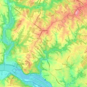
Name: Darnestown topographic map, elevation, terrain.
Location: Darnestown, Montgomery County, Maryland, United States (39.04629 -77.34358 39.13403 -77.24729)
Average elevation: 318 ft
Minimum elevation: 154 ft
Maximum elevation: 505 ft
Montgomery County trails, hiking, mountain biking, running and outdoor activities
Other topographic maps
Click on a map to view its topography, its elevation and its terrain.
Quail Ridge
United States > Maryland > Montgomery County > Montgomery Village
Average elevation: 436 ft
Brookeville Heights
United States > Maryland > Montgomery County > Brookeville Heights
Average elevation: 456 ft
Great Falls
United States > Maryland > Montgomery County > Potomac
The rocks of the falls date to the late Precambrian and are about 750 million years old. The rocks are a resistant metamorphized schist, gneisses, metagraywackes, and metaconglomerates. The Falls formed the last time sea level dropped, during the Last Glacial Period about 35,000 years ago, causing the Potomac…
Average elevation: 240 ft
Seneca
United States > Maryland > Montgomery County > Darnestown
Seneca is located close to the intersection of River Road (Maryland Route 190), Seneca Road (Maryland route 112), and Rileys Lock Road, east of Great Seneca Creek and north of the Potomac River. The C&O Canal runs along the river, and Riley's Lock is the closest canal lock. The southern portion of Seneca Creek…
Average elevation: 269 ft
Rockcrest
United States > Maryland > Montgomery County > Rockville > Rockcrest
Average elevation: 374 ft
Garrett Park Estates
United States > Maryland > Montgomery County > Garrett Park Estates
Average elevation: 318 ft