
Town of Wawayanda topographic map
Interactive map
Click on the map to display elevation.
About this map
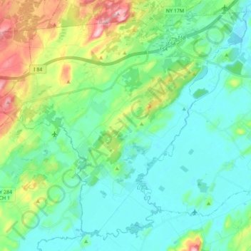
Name: Town of Wawayanda topographic map, elevation, terrain.
Location: Town of Wawayanda, Orange County, New York, United States (41.31351 -74.54562 41.43104 -74.37357)
Average elevation: 512 ft
Minimum elevation: 358 ft
Maximum elevation: 994 ft
Other topographic maps
Click on a map to view its topography, its elevation and its terrain.
Godeffroy
United States > New York > Orange County
Godeffroy, Town of Deerpark, Orange County, New York, 12739, United States
Average elevation: 705 ft
Salisbury Mills
United States > New York > Orange County > Town of Cornwall
Salisbury Mills, Town of Cornwall, Orange County, New York, United States
Average elevation: 381 ft
Village of Maybrook
United States > New York > Orange County
Village of Maybrook, Town of Montgomery, Orange County, New York, 12543, United States
Average elevation: 397 ft
Town of Greenville
United States > New York > Orange County
Town of Greenville, Orange County, New York, United States
Average elevation: 866 ft
Village of Florida
United States > New York > Orange County > Town of Warwick
Village of Florida, Town of Warwick, Orange County, New York, 10921, United States
Average elevation: 492 ft
City of Newburgh
United States > New York > Orange County
City of Newburgh, Orange County, New York, United States
Average elevation: 105 ft
Harriman State Park
United States > New York > Orange County > Town of Tuxedo
Harriman State Park, Town of Tuxedo, Town of Highlands, Orange County, New York, United States
Average elevation: 719 ft
Town of Mount Hope
United States > New York > Orange County
Town of Mount Hope, Orange County, New York, 10963, United States
Average elevation: 810 ft
Village of Warwick
United States > New York > Orange County > Town of Warwick
Village of Warwick, Town of Warwick, Orange County, New York, United States
Average elevation: 614 ft
Vails Gate
United States > New York > Orange County > Town of New Windsor
Vails Gate, Town of New Windsor, Orange County, New York, 12584, United States
Average elevation: 282 ft
Scotchtown
United States > New York > Orange County
Scotchtown, Town of Wallkill, Orange County, New York, 10941, United States
Average elevation: 604 ft
East Walden
United States > New York > Orange County > Town of Montgomery
East Walden, Town of Montgomery, Orange County, New York, 12586, United States
Average elevation: 397 ft
Village of South Blooming Grove
United States > New York > Orange County
Village of South Blooming Grove, Town of Blooming Grove, Orange County, New York, United States
Average elevation: 617 ft
Warwick
United States > New York > Orange County
Warwick, Town of Warwick, Orange County, New York, United States
Average elevation: 696 ft
Town of Cornwall
United States > New York > Orange County
Town of Cornwall, Orange County, New York, United States
Average elevation: 597 ft
Village of Highland Falls
United States > New York > Orange County
Village of Highland Falls, Town of Highlands, Orange County, New York, United States
Average elevation: 305 ft
Gardnertown
United States > New York > Orange County
Gardnertown, Town of Newburgh, Orange County, New York, 12550, United States
Average elevation: 449 ft
Village of Otisville
United States > New York > Orange County > Town of Mount Hope
Village of Otisville, Town of Mount Hope, Orange County, New York, United States
Average elevation: 892 ft
Town of Tuxedo
United States > New York > Orange County
Town of Tuxedo, Orange County, New York, United States
Average elevation: 863 ft
Bullville
United States > New York > Orange County
Bullville, Town of Crawford, Orange County, New York, 10915, United States
Average elevation: 535 ft
City of Port Jervis
United States > New York > Orange County
City of Port Jervis, Orange County, New York, United States
Average elevation: 528 ft
Cornwall Landing
United States > New York > Orange County > Village of Cornwall-on-Hudson
Cornwall Landing, Village of Cornwall-on-Hudson, Town of Cornwall, Orange County, New York, 12520, United States
Average elevation: 243 ft
Balmville
United States > New York > Orange County
Balmville, Town of Newburgh, Orange County, New York, United States
Average elevation: 289 ft
Berea
United States > New York > Orange County > Town of Montgomery
Berea, Town of Montgomery, Orange County, New York, 12586, United States
Average elevation: 410 ft
Town of Hamptonburgh
United States > New York > Orange County
Town of Hamptonburgh, Orange County, New York, 10916, United States
Average elevation: 417 ft
Appalachian National Scenic Trail
United States > New York > Orange County > Village of Greenwood Lake
Appalachian National Scenic Trail, Village of Greenwood Lake, Town of Tuxedo, Orange County, New York, United States
Average elevation: 899 ft
Huguenot
United States > New York > Orange County
Huguenot, Town of Deerpark, Orange County, New York, 12746, United States
Average elevation: 636 ft
Village of Montgomery
United States > New York > Orange County
Village of Montgomery, Town of Montgomery, Orange County, New York, 12549, United States
Average elevation: 387 ft
Town of Crawford
United States > New York > Orange County
Town of Crawford, Orange County, New York, United States
Average elevation: 453 ft
Mount Peter
United States > New York > Orange County > Town of Warwick
Mount Peter, Town of Warwick, Orange County, New York, 10912, United States
Average elevation: 873 ft
Howell
United States > New York > Orange County > Town of Goshen
Howell, Town of Goshen, Orange County, New York, 10924, United States
Average elevation: 518 ft
Town of Blooming Grove
United States > New York > Orange County
Town of Blooming Grove, Orange County, New York, United States
Average elevation: 577 ft
Village of Tuxedo Park
United States > New York > Orange County
Village of Tuxedo Park, Town of Tuxedo, Orange County, New York, 10987, United States
Average elevation: 755 ft
Town of Chester
United States > New York > Orange County
Town of Chester, Orange County, New York, United States
Average elevation: 620 ft
Bellvale
United States > New York > Orange County > Town of Warwick
Bellvale, Town of Warwick, Orange County, New York, 10912, United States
Average elevation: 741 ft
Village of Chester
United States > New York > Orange County
Village of Chester, Town of Chester, Orange County, New York, 10918, United States
Average elevation: 502 ft
Mechanicstown
United States > New York > Orange County
Mechanicstown, Town of Wallkill, Orange County, New York, United States
Average elevation: 545 ft
Town of Montgomery
United States > New York > Orange County
Town of Montgomery, Orange County, New York, United States
Average elevation: 420 ft
Town of New Windsor
United States > New York > Orange County
Town of New Windsor, Orange County, New York, United States
Average elevation: 381 ft
Village of Walden
United States > New York > Orange County
Village of Walden, Town of Montgomery, Orange County, New York, 12586, United States
Average elevation: 374 ft
Village of Unionville
United States > New York > Orange County
Village of Unionville, Town of Minisink, Orange County, New York, 10988, United States
Average elevation: 607 ft
Highland Mills
United States > New York > Orange County > Village of Woodbury
Highland Mills, Village of Woodbury, Town of Woodbury, Orange County, New York, 10930, United States
Average elevation: 682 ft
Schunnemunk State Park
United States > New York > Orange County > Village of Woodbury
Schunnemunk State Park, Village of Woodbury, Town of Woodbury, Town of Cornwall, Orange County, New York, United States
Average elevation: 699 ft
North Dock
United States > New York > Orange County
North Dock, Town of Highlands, Orange County, New York, 10996, United States
Average elevation: 249 ft
Village of Goshen
United States > New York > Orange County > Town of Goshen
Village of Goshen, Town of Goshen, Orange County, New York, 10924, United States
Average elevation: 463 ft
Town of Wallkill
United States > New York > Orange County
Town of Wallkill, Orange County, New York, United States
Average elevation: 554 ft
Newburgh
United States > New York > Orange County > Newburgh
Newburgh, Orange County, New York, 12550, United States
Average elevation: 482 ft
Monroe
United States > New York > Orange County > Monroe > Monroe
Monroe, Town of Monroe, Orange County, New York, 10950, United States
Average elevation: 719 ft
Walton Park
United States > New York > Orange County > Town of Monroe
Walton Park, Town of Monroe, Orange County, New York, United States
Average elevation: 699 ft
Town of Goshen
United States > New York > Orange County
Town of Goshen, Orange County, New York, United States
Average elevation: 479 ft