
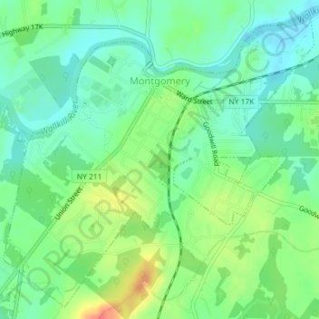
Village of Montgomery topographic map
Interactive map
Click on the map to display elevation.
About this map
Name: Village of Montgomery topographic map, elevation, terrain.
Average elevation: 387 ft
Minimum elevation: 325 ft
Maximum elevation: 495 ft
These lands in the west are the lowest-lying in the village. Much of its topography rises gently from the river, with little relief save the Academy Hill area on the east edge of downtown where the village hall is located, and a 455-foot (139 m) hill at the junction of Purple Martin Road and Cardinal Drive that is the highest point in the village, marked by a water tower.
Other topographic maps
Click on a map to view its topography, its elevation and its terrain.
Godeffroy
United States > New York > Orange County
Godeffroy, Town of Deerpark, Orange County, New York, 12739, United States
Average elevation: 705 ft
Salisbury Mills
United States > New York > Orange County > Town of Cornwall
Salisbury Mills, Town of Cornwall, Orange County, New York, United States
Average elevation: 381 ft
Village of Maybrook
United States > New York > Orange County
Village of Maybrook, Town of Montgomery, Orange County, New York, 12543, United States
Average elevation: 397 ft
Town of Greenville
United States > New York > Orange County
Town of Greenville, Orange County, New York, United States
Average elevation: 866 ft
Village of Florida
United States > New York > Orange County > Town of Warwick
Village of Florida, Town of Warwick, Orange County, New York, 10921, United States
Average elevation: 492 ft
City of Newburgh
United States > New York > Orange County
City of Newburgh, Orange County, New York, United States
Average elevation: 105 ft
Harriman State Park
United States > New York > Orange County > Town of Tuxedo
Harriman State Park, Town of Tuxedo, Town of Highlands, Orange County, New York, United States
Average elevation: 719 ft
Town of Wawayanda
United States > New York > Orange County
Town of Wawayanda, Orange County, New York, United States
Average elevation: 512 ft
Town of Mount Hope
United States > New York > Orange County
Town of Mount Hope, Orange County, New York, 10963, United States
Average elevation: 810 ft
Village of Warwick
United States > New York > Orange County > Town of Warwick
Village of Warwick, Town of Warwick, Orange County, New York, United States
Average elevation: 614 ft
Vails Gate
United States > New York > Orange County > Town of New Windsor
Vails Gate, Town of New Windsor, Orange County, New York, 12584, United States
Average elevation: 282 ft
Scotchtown
United States > New York > Orange County
Scotchtown, Town of Wallkill, Orange County, New York, 10941, United States
Average elevation: 604 ft
East Walden
United States > New York > Orange County > Town of Montgomery
East Walden, Town of Montgomery, Orange County, New York, 12586, United States
Average elevation: 397 ft
Village of South Blooming Grove
United States > New York > Orange County
Village of South Blooming Grove, Town of Blooming Grove, Orange County, New York, United States
Average elevation: 617 ft
Warwick
United States > New York > Orange County
Warwick, Town of Warwick, Orange County, New York, United States
Average elevation: 696 ft
Town of Cornwall
United States > New York > Orange County
Town of Cornwall, Orange County, New York, United States
Average elevation: 597 ft
Village of Highland Falls
United States > New York > Orange County
Village of Highland Falls, Town of Highlands, Orange County, New York, United States
Average elevation: 305 ft
Gardnertown
United States > New York > Orange County
Gardnertown, Town of Newburgh, Orange County, New York, 12550, United States
Average elevation: 449 ft
Village of Otisville
United States > New York > Orange County > Town of Mount Hope
Village of Otisville, Town of Mount Hope, Orange County, New York, United States
Average elevation: 892 ft
Town of Tuxedo
United States > New York > Orange County
Town of Tuxedo, Orange County, New York, United States
Average elevation: 863 ft
Bullville
United States > New York > Orange County
Bullville, Town of Crawford, Orange County, New York, 10915, United States
Average elevation: 535 ft
City of Port Jervis
United States > New York > Orange County
City of Port Jervis, Orange County, New York, United States
Average elevation: 528 ft
Cornwall Landing
United States > New York > Orange County > Village of Cornwall-on-Hudson
Cornwall Landing, Village of Cornwall-on-Hudson, Town of Cornwall, Orange County, New York, 12520, United States
Average elevation: 243 ft
Balmville
United States > New York > Orange County
Balmville, Town of Newburgh, Orange County, New York, United States
Average elevation: 289 ft
Berea
United States > New York > Orange County > Town of Montgomery
Berea, Town of Montgomery, Orange County, New York, 12586, United States
Average elevation: 410 ft
Town of Hamptonburgh
United States > New York > Orange County
Town of Hamptonburgh, Orange County, New York, 10916, United States
Average elevation: 417 ft
Appalachian National Scenic Trail
United States > New York > Orange County > Village of Greenwood Lake
Appalachian National Scenic Trail, Village of Greenwood Lake, Town of Tuxedo, Orange County, New York, United States
Average elevation: 899 ft
Huguenot
United States > New York > Orange County
Huguenot, Town of Deerpark, Orange County, New York, 12746, United States
Average elevation: 636 ft
Town of Crawford
United States > New York > Orange County
Town of Crawford, Orange County, New York, United States
Average elevation: 453 ft
Mount Peter
United States > New York > Orange County > Town of Warwick
Mount Peter, Town of Warwick, Orange County, New York, 10912, United States
Average elevation: 873 ft
Howell
United States > New York > Orange County > Town of Goshen
Howell, Town of Goshen, Orange County, New York, 10924, United States
Average elevation: 518 ft
Town of Blooming Grove
United States > New York > Orange County
Town of Blooming Grove, Orange County, New York, United States
Average elevation: 577 ft
Village of Tuxedo Park
United States > New York > Orange County
Village of Tuxedo Park, Town of Tuxedo, Orange County, New York, 10987, United States
Average elevation: 755 ft
Town of Chester
United States > New York > Orange County
Town of Chester, Orange County, New York, United States
Average elevation: 620 ft
Bellvale
United States > New York > Orange County > Town of Warwick
Bellvale, Town of Warwick, Orange County, New York, 10912, United States
Average elevation: 741 ft
Village of Chester
United States > New York > Orange County
Village of Chester, Town of Chester, Orange County, New York, 10918, United States
Average elevation: 502 ft
Mechanicstown
United States > New York > Orange County
Mechanicstown, Town of Wallkill, Orange County, New York, United States
Average elevation: 545 ft
Town of Montgomery
United States > New York > Orange County
Town of Montgomery, Orange County, New York, United States
Average elevation: 420 ft
Town of New Windsor
United States > New York > Orange County
Town of New Windsor, Orange County, New York, United States
Average elevation: 381 ft
Village of Walden
United States > New York > Orange County
Village of Walden, Town of Montgomery, Orange County, New York, 12586, United States
Average elevation: 374 ft
Village of Unionville
United States > New York > Orange County
Village of Unionville, Town of Minisink, Orange County, New York, 10988, United States
Average elevation: 607 ft
Highland Mills
United States > New York > Orange County > Village of Woodbury
Highland Mills, Village of Woodbury, Town of Woodbury, Orange County, New York, 10930, United States
Average elevation: 682 ft
Schunnemunk State Park
United States > New York > Orange County > Village of Woodbury
Schunnemunk State Park, Village of Woodbury, Town of Woodbury, Town of Cornwall, Orange County, New York, United States
Average elevation: 699 ft
North Dock
United States > New York > Orange County
North Dock, Town of Highlands, Orange County, New York, 10996, United States
Average elevation: 249 ft
Village of Goshen
United States > New York > Orange County > Town of Goshen
Village of Goshen, Town of Goshen, Orange County, New York, 10924, United States
Average elevation: 463 ft
Town of Wallkill
United States > New York > Orange County
Town of Wallkill, Orange County, New York, United States
Average elevation: 554 ft
Newburgh
United States > New York > Orange County > Newburgh
Newburgh, Orange County, New York, 12550, United States
Average elevation: 482 ft
Monroe
United States > New York > Orange County > Monroe > Monroe
Monroe, Town of Monroe, Orange County, New York, 10950, United States
Average elevation: 719 ft
Walton Park
United States > New York > Orange County > Town of Monroe
Walton Park, Town of Monroe, Orange County, New York, United States
Average elevation: 699 ft
Town of Goshen
United States > New York > Orange County
Town of Goshen, Orange County, New York, United States
Average elevation: 479 ft