
Make a donation
Gear up for your next adventure:
As an Amazon Associate, this site earns from qualifying purchases at no extra cost to you.
Great Plumstead topographic map
Click on the map to display elevation.
Make a donation
Gear up for your next adventure:
As an Amazon Associate, this site earns from qualifying purchases at no extra cost to you.
About this map
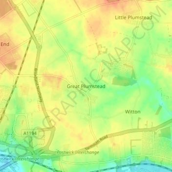
Name: Great Plumstead topographic map, elevation, terrain.
Average elevation: 72 ft
Minimum elevation: -3 ft
Maximum elevation: 128 ft
Make a donation
Gear up for your next adventure:
As an Amazon Associate, this site earns from qualifying purchases at no extra cost to you.
Other topographic maps
Click on a map to view its topography, its elevation and its terrain.
Make a donation
Gear up for your next adventure:
As an Amazon Associate, this site earns from qualifying purchases at no extra cost to you.
Strumpshaw
United Kingdom > England > Norfolk > Broadland
The village lies a little distance from the river, on the slopes of Strumpshaw Hill, the highest area of land in the Norfolk Broads. Because of its elevation, Strumpshaw hosted, from the late 1790s through to the mid-1810s, a repeater station in the shutter telegraph chain linking the Admiralty in London with…
Average elevation: 36 ft
Make a donation
Gear up for your next adventure:
As an Amazon Associate, this site earns from qualifying purchases at no extra cost to you.
Make a donation
Gear up for your next adventure:
As an Amazon Associate, this site earns from qualifying purchases at no extra cost to you.
Heydon
United Kingdom > England > Norfolk > Broadland
By the village green there is an 18th-century public house – The Earle Arms – which is grade II listed and has a "Regionally Important Historic Interior". It was until circa 1845 called the Lion and Lamb. It is believed that a pub has existed at this location since the 16th century, and was a coaching inn.…
Average elevation: 144 ft
Great Witchingham Village Hall Park
United Kingdom > England > Norfolk > Broadland > Lenwade > Great Witchingham
Average elevation: 85 ft
Make a donation
Gear up for your next adventure:
As an Amazon Associate, this site earns from qualifying purchases at no extra cost to you.
Haveringland Lake
United Kingdom > England > Norfolk > Broadland > Haveringland
Average elevation: 128 ft
Make a donation
Gear up for your next adventure:
As an Amazon Associate, this site earns from qualifying purchases at no extra cost to you.
Blickling Hall
United Kingdom > England > Norfolk > Broadland > Blickling > Silvergate
Average elevation: 92 ft
Make a donation
Gear up for your next adventure:
As an Amazon Associate, this site earns from qualifying purchases at no extra cost to you.
Make a donation
Gear up for your next adventure:
As an Amazon Associate, this site earns from qualifying purchases at no extra cost to you.
Make a donation
Gear up for your next adventure:
As an Amazon Associate, this site earns from qualifying purchases at no extra cost to you.
Make a donation
Gear up for your next adventure:
As an Amazon Associate, this site earns from qualifying purchases at no extra cost to you.
Make a donation
Gear up for your next adventure:
As an Amazon Associate, this site earns from qualifying purchases at no extra cost to you.
Make a donation
Gear up for your next adventure:
As an Amazon Associate, this site earns from qualifying purchases at no extra cost to you.
Make a donation
Gear up for your next adventure:
As an Amazon Associate, this site earns from qualifying purchases at no extra cost to you.