Geolocate

Colán topographic map

Click on the map to display elevation.

About this map

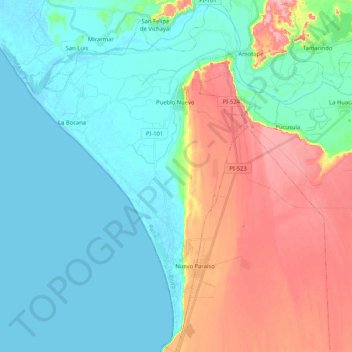
Name: Colán topographic map, elevation, terrain.

Location: Colán, Province of Paita, Piura, Peru (-5.05651 -81.15175 -4.85034 -81.01689)

Average elevation: 112 ft

Minimum elevation: -7 ft

Maximum elevation: 361 ft

Other topographic maps

Click on a map to view its topography, its elevation and its terrain.

San Pablo

Peru > Piura > Pacaipampa > Lagunas De San Pablo

Average elevation: 7,005 ft

San Pablo

Peru > Piura > Pacaipampa > Lagunas De San Pablo

Average elevation: 7,005 ft

Tambogrande

Peru > Piura > Tambo Grande

Average elevation: 240 ft

Vichayito

Peru > Piura > Los Órganos

Average elevation: 56 ft

Mexico

Peru > Piura > Pacaipampa

Average elevation: 6,896 ft

Fb

Peru > Piura > 26 de Octubre

Average elevation: 131 ft

El Salto

Peru > Piura > Tambo Grande

Average elevation: 240 ft

Sicchez

Peru > Piura > Sícchez

Average elevation: 5,135 ft

Jilili

Peru > Piura > Jililí

Average elevation: 5,121 ft

Sapalache

Peru > Piura > El Carmen de la Frontera

Average elevation: 8,130 ft

Qf

Peru > Piura > 26 de Octubre

Average elevation: 135 ft

Mejia

Peru > Piura > Sullana

Average elevation: 253 ft

Locuto

Peru > Piura > Tambo Grande

Average elevation: 236 ft

Locuto

Peru > Piura > Tambo Grande

Average elevation: 236 ft

Frias

Peru > Piura > Frías

Average elevation: 6,056 ft

Las Vegas

Peru > Piura > Sícchez

Average elevation: 4,173 ft

Pico de Loro

Peru > Piura > Jililí

Average elevation: 3,894 ft

Sicchez

Peru > Piura > Sícchez

Average elevation: 5,135 ft

Lobitos

Peru > Piura

Average elevation: 43 ft

Nuevo Pozo Oscuro

Peru > Piura > Cristo nos Valga

Average elevation: 72 ft

Rinconada

Peru > Piura > Rinconada Llicuar

Average elevation: 33 ft

Pico de Loro

Peru > Piura > Jililí

Average elevation: 3,894 ft

Narihualá

Peru > Piura > Catacaos

Average elevation: 72 ft

Chira

Peru > Piura > Sullana

Average elevation: 164 ft

Mancora

Peru > Piura > Máncora

Average elevation: 72 ft

Talara

Peru > Piura > Pariñas

Average elevation: 138 ft

Pico de Loro

Peru > Piura > Jililí

Average elevation: 3,894 ft

Gear up for your next adventure:

🧴Hand Sanitizer - Keep hands clean while hiking
📱Solar Portable Charger - Solar power bank for charging devices off‑grid
🔋Solar Power Banks - Keep your GPS and phone charged in remote wilderness areas
🧭Hiking Compass - Precision compass for reliable navigation in the wilderness
🧭Compass with Lanyard - Easy‑carry compass for navigation

As an Amazon Associate, this site earns from qualifying purchases at no extra cost to you.