Geolocate

Zion topographic map

Click on the map to display elevation.

About this map

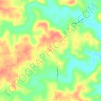
Name: Zion topographic map, elevation, terrain.

Location: Zion, Izard County, Arkansas, 72573, United States (36.06035 -91.78987 36.10035 -91.74987)

Average elevation: 650 ft

Minimum elevation: 551 ft

Maximum elevation: 745 ft

Izard County trails, hiking, mountain biking, running and outdoor activities

Other topographic maps

Click on a map to view its topography, its elevation and its terrain.

Mount Pleasant

United States > Arkansas > Izard County

Average elevation: 673 ft

Franklin

United States > Arkansas > Izard County

Average elevation: 666 ft

Guion

United States > Arkansas > Izard County

Average elevation: 466 ft

Pineville

United States > Arkansas > Izard County

Average elevation: 653 ft

Melbourne

United States > Arkansas > Izard County

Average elevation: 659 ft

Gear up for your next adventure:

⛑️Personal Locator Beacon - Safety beacon for emergencies
🔊Portable Camp Speaker - Music and alerts at camp
🕶️GPS Smartphone Mount - Secure mount for phone navigation
🛠️Outdoor Gear Repair Kit - Essential tools to fix gear on the trail
🥘Titanium Cookware - Durable, featherlight pots and pans for backpacking

As an Amazon Associate, this site earns from qualifying purchases at no extra cost to you.