Geolocate

Morcombelake topographic map

Click on the map to display elevation.

About this map
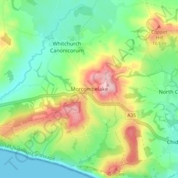
Name: Morcombelake topographic map, elevation, terrain.

Location: Morcombelake, Dorset, England, DT6 6EA, United Kingdom (50.72435 -2.87077 50.76435 -2.83077)

Average elevation: 243 ft

Minimum elevation: 0 ft

Maximum elevation: 676 ft

Other topographic maps

Click on a map to view its topography, its elevation and its terrain.
Jurassic Coast

United Kingdom > England > Dorset > Bridport

Average elevation: 161 ft

Isle of Portland

United Kingdom > England > Dorset > Wyke Regis

In Museums Without Walls, Jonathan Meades declares that "Portland is a bulky chunk of geological, social, topographical and demographic weirdness. It is the obverse of a beauty spot. 'Beauty' in this construction implies the picturesque. Portland is gloriously bereft of this quality. It is awesome. There is…

Average elevation: 36 ft
Ridge

United Kingdom > England > Dorset > Wareham > Ridge

Average elevation: 23 ft

Evershot

United Kingdom > England > Dorset

Average elevation: 512 ft

Ashmore

United Kingdom > England > Dorset

Average elevation: 591 ft

Frampton

United Kingdom > England > Dorset > Frampton

Average elevation: 430 ft

West Dorset

United Kingdom > England > Dorset

Average elevation: 243 ft

Toller Porcorum

United Kingdom > England > Dorset > Toller Porcorum

Average elevation: 502 ft

Wool

United Kingdom > England > Dorset > Bovington

Average elevation: 121 ft

Nether Compton

United Kingdom > England > Dorset

Average elevation: 279 ft

Burning Cliff

United Kingdom > England > Dorset > South Holworth

Average elevation: 210 ft

Manston

United Kingdom > England > Dorset

Average elevation: 167 ft

Wimborne Minster

United Kingdom > England > Dorset

Average elevation: 102 ft

Gear up for your next adventure:

🛡️Bear Spray Outdoor - Protection in bear country hikes
💧Water Purification System - Clean water on the trail with reliable purifiers
🪑Ultralight Camp Chairs - Portable seating for resting after a long day of mapping
💧Water Filtration Bottles - Safely drink from streams and lakes while exploring
🏕️Tent Footprint - Protect your tent base from wear

As an Amazon Associate, this site earns from qualifying purchases at no extra cost to you.