
Thank you for supporting this site ❤️
Make a donation
Make a donation
Gear up for your next adventure:
As an Amazon Associate, this site earns from qualifying purchases at no extra cost to you.
剑川县 topographic map
Click on the map to display elevation.
Thank you for supporting this site ❤️
Make a donation
Make a donation
Gear up for your next adventure:
As an Amazon Associate, this site earns from qualifying purchases at no extra cost to you.
剑川县
剑川县最高点是雪斑山主峰,海拔4,295米,最低点为沙溪米子坪,海拔1,973米,县城海拔2,195米。
Thank you for supporting this site ❤️
Make a donation
Make a donation
Gear up for your next adventure:
As an Amazon Associate, this site earns from qualifying purchases at no extra cost to you.
About this map
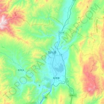
Name: 剑川县 topographic map, elevation, terrain.
Location: 剑川县, 大理白族自治州, 云南省, 中国 (26.38006 99.74459 26.70006 100.06459)
Average elevation: 8,930 ft
Minimum elevation: 7,139 ft
Maximum elevation: 13,520 ft
Thank you for supporting this site ❤️
Make a donation
Make a donation
Gear up for your next adventure:
As an Amazon Associate, this site earns from qualifying purchases at no extra cost to you.
Other topographic maps
Click on a map to view its topography, its elevation and its terrain.