Geolocate

Dickson topographic map

Click on the map to display elevation.

About this map

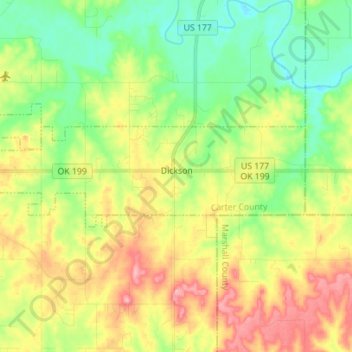
Name: Dickson topographic map, elevation, terrain.

Location: Dickson, Carter County, Oklahoma, United States (34.16883 -97.07315 34.20185 -96.93344)

Average elevation: 807 ft

Minimum elevation: 656 ft

Maximum elevation: 1,020 ft

Carter County trails, hiking, mountain biking, running and outdoor activities

Other topographic maps

Click on a map to view its topography, its elevation and its terrain.

Graham

United States > Oklahoma > Carter County

Average elevation: 942 ft

Tussy

United States > Oklahoma > Carter County

Average elevation: 974 ft

Fox

United States > Oklahoma > Carter County

Average elevation: 981 ft

Milo

United States > Oklahoma > Carter County

Average elevation: 906 ft

Pooleville

United States > Oklahoma > Carter County

Average elevation: 1,043 ft

Gear up for your next adventure:

📱Heavy-Duty Phone Cases - Drop-proof and waterproof protection for outdoor navigation
🌧️Backpack Rain Cover - Keep gear dry in wet weather
🌲Outdoor Survival Books - Best books on survival skills
📡GPS Antenna Upgrade - Enhance GPS reception in remote terrain
🏕️Tent Footprint - Protect your tent base from wear

As an Amazon Associate, this site earns from qualifying purchases at no extra cost to you.