Geolocate

Pooleville topographic map

Click on the map to display elevation.

About this map

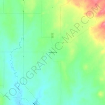
Name: Pooleville topographic map, elevation, terrain.

Location: Pooleville, Carter County, Oklahoma, United States (34.39953 -97.41975 34.43953 -97.37975)

Average elevation: 1,043 ft

Minimum elevation: 951 ft

Maximum elevation: 1,220 ft

Carter County trails, hiking, mountain biking, running and outdoor activities

Other topographic maps

Click on a map to view its topography, its elevation and its terrain.

Ratliff City

United States > Oklahoma > Carter County

Average elevation: 1,033 ft

Springer

United States > Oklahoma > Carter County

Average elevation: 850 ft

Tatums

United States > Oklahoma > Carter County

Average elevation: 974 ft

Dickson

United States > Oklahoma > Carter County

Average elevation: 807 ft

Lake Murray

United States > Oklahoma > Carter County > Ardmore

Average elevation: 787 ft

Wilson

United States > Oklahoma > Carter County

Average elevation: 938 ft

Lone Grove

United States > Oklahoma > Carter County

Average elevation: 899 ft

Gear up for your next adventure:

🪶Multi‑Purpose Knife - Useful blade for camp and trail
🛠️Backpacking Tool Kit - Essential toolkit for outdoor repairs
🩳Quick‑Dry Hiking Shorts - Comfortable and quick‑dry shorts for summer hiking
🧷Carabiner Set - Durable clips for gear attachment
🌐World Map Poster - Decorative world maps with topographic info

As an Amazon Associate, this site earns from qualifying purchases at no extra cost to you.