Geolocate

Graham topographic map

Click on the map to display elevation.

About this map

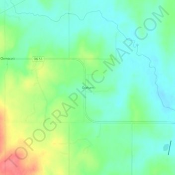
Name: Graham topographic map, elevation, terrain.

Location: Graham, Carter County, Oklahoma, 73437, United States (34.32064 -97.45447 34.36064 -97.41447)

Average elevation: 942 ft

Minimum elevation: 866 ft

Maximum elevation: 1,093 ft

Carter County trails, hiking, mountain biking, running and outdoor activities

Other topographic maps

Click on a map to view its topography, its elevation and its terrain.

Ratliff City

United States > Oklahoma > Carter County

Average elevation: 1,033 ft

Springer

United States > Oklahoma > Carter County

Average elevation: 850 ft

Tatums

United States > Oklahoma > Carter County

Average elevation: 974 ft

Dickson

United States > Oklahoma > Carter County

Average elevation: 807 ft

Lake Murray

United States > Oklahoma > Carter County > Ardmore

Average elevation: 787 ft

Wilson

United States > Oklahoma > Carter County

Average elevation: 938 ft

Lone Grove

United States > Oklahoma > Carter County

Average elevation: 899 ft

Gear up for your next adventure:

📦Gear Storage Bags - Organize and protect outdoor equipment
🛠️Outdoor Gear Repair Kit - Essential tools to fix gear on the trail
📚Navigation Handbooks - Master the art of reading topographic maps and using a compass
🧤Hiking Gloves - Protective gloves for rugged trails
💧Water Filtration Bottles - Safely drink from streams and lakes while exploring

As an Amazon Associate, this site earns from qualifying purchases at no extra cost to you.