Geolocate

Fox topographic map

Click on the map to display elevation.

About this map

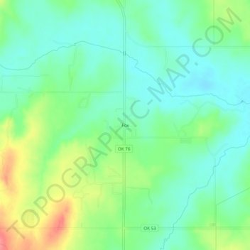
Name: Fox topographic map, elevation, terrain.

Location: Fox, Carter County, Oklahoma, 73435, United States (34.34370 -97.51225 34.38370 -97.47225)

Average elevation: 981 ft

Minimum elevation: 899 ft

Maximum elevation: 1,152 ft

Carter County trails, hiking, mountain biking, running and outdoor activities

Other topographic maps

Click on a map to view its topography, its elevation and its terrain.

Ratliff City

United States > Oklahoma > Carter County

Average elevation: 1,033 ft

Springer

United States > Oklahoma > Carter County

Average elevation: 850 ft

Tatums

United States > Oklahoma > Carter County

Average elevation: 974 ft

Dickson

United States > Oklahoma > Carter County

Average elevation: 807 ft

Lake Murray

United States > Oklahoma > Carter County > Ardmore

Average elevation: 787 ft

Wilson

United States > Oklahoma > Carter County

Average elevation: 938 ft

Lone Grove

United States > Oklahoma > Carter County

Average elevation: 899 ft

Gear up for your next adventure:

🪵Folding Camp Saw - Compact saw for wood and campsite work
🥩Freeze-Dried Meals - Nutritious and lightweight food for remote expeditions
GPS Sports Watch - GPS watch for running, hiking and training
🎒Trail Energy Bars - High‑calorie bars for hiking energy
🚁Photography Drones - Capture stunning aerial views of landforms and topography

As an Amazon Associate, this site earns from qualifying purchases at no extra cost to you.