
洪山咀 topographic map
Interactive map
Click on the map to display elevation.
About this map
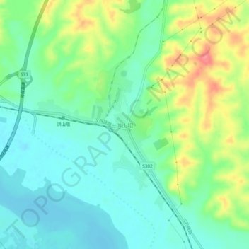
Name: 洪山咀 topographic map, elevation, terrain.
Location: 洪山咀, 襄阳市, 湖北省, 中国 (32.43453 111.64028 32.47453 111.68028)
Average elevation: 358 ft
Minimum elevation: 269 ft
Maximum elevation: 541 ft
Other topographic maps
Click on a map to view its topography, its elevation and its terrain.