
Make a donation
Gear up for your next adventure:
As an Amazon Associate, this site earns from qualifying purchases at no extra cost to you.
Albano Laziale topographic map
Click on the map to display elevation.
Make a donation
Gear up for your next adventure:
As an Amazon Associate, this site earns from qualifying purchases at no extra cost to you.
Albano Laziale
The highest peak of the town of Albano is the Colle dei Cappuccini, located at 615 m above sea level. From the hill, which houses a pine forest adjacent to the Capuchin Monastery, there is a remarkable overview of Lake Albano, Agro Romano and Monte Cavo. The historic center of Albano has a maximum gradient of 11%, or 47 metres, 435, taking into consideration the distance between the Cathedral of San Pancrazio (384 m asl) and the St. Paul's Church (431 m asl). Other altitudes through the center of town are Villa Altieri, at kilometre 25 of the State Road 7 Via Appia (363 m asl) and the Church of Stella (391 m asl). The hill town of Castel Savelli is 280 m above sea level, while the underlying fraction of Pavona is built at 110 m above sea level. The village of Cecchina at the railway station is located at 212 m above sea level.
Make a donation
Gear up for your next adventure:
As an Amazon Associate, this site earns from qualifying purchases at no extra cost to you.
About this map
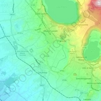
Name: Albano Laziale topographic map, elevation, terrain.
Location: Albano Laziale, Roma Capitale, Lazio, 00041, Italy (41.67321 12.59029 41.75334 12.69444)
Average elevation: 991 ft
Minimum elevation: 348 ft
Maximum elevation: 3,120 ft
Make a donation
Gear up for your next adventure:
As an Amazon Associate, this site earns from qualifying purchases at no extra cost to you.
Other topographic maps
Click on a map to view its topography, its elevation and its terrain.
Rome
Italy > Lazio > Roma Capitale
Although the city centre is about 24 km (15 mi) inland from the Tyrrhenian Sea, the city territory extends to the shore, where the south-western district of Ostia is located. The altitude of the central part of Rome ranges from 13 m (43 ft) above sea level (at the base of the Pantheon) to 139 m (456 ft) above…
Average elevation: 256 ft
Make a donation
Gear up for your next adventure:
As an Amazon Associate, this site earns from qualifying purchases at no extra cost to you.
Make a donation
Gear up for your next adventure:
As an Amazon Associate, this site earns from qualifying purchases at no extra cost to you.
Make a donation
Gear up for your next adventure:
As an Amazon Associate, this site earns from qualifying purchases at no extra cost to you.
Make a donation
Gear up for your next adventure:
As an Amazon Associate, this site earns from qualifying purchases at no extra cost to you.