Geolocate

Lake Limestone topographic map

Click on the map to display elevation.

About this map

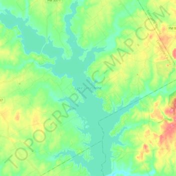
Name: Lake Limestone topographic map, elevation, terrain.

Location: Lake Limestone, Limestone County, Texas, United States (31.32567 -96.43727 31.48102 -96.27921)

Average elevation: 410 ft

Minimum elevation: 335 ft

Maximum elevation: 574 ft

Limestone County trails, hiking, mountain biking, running and outdoor activities

Other topographic maps

Click on a map to view its topography, its elevation and its terrain.

Morgan Hill

United States > Texas > Limestone County

Average elevation: 512 ft

Groesbeck

United States > Texas > Limestone County > Groesbeck > Groesbeck

Average elevation: 456 ft

Mexia

United States > Texas > Limestone County

Average elevation: 499 ft

Mexia

United States > Texas > Limestone County > Mexia > Mexia

Average elevation: 505 ft

LaSalle

United States > Texas > Limestone County > LaSalle

Average elevation: 446 ft

Gear up for your next adventure:

🪶Trail Camera - Capture wildlife on your hikes
🔦LED Headlamp - Bright and durable LED headlamp for night navigation
🧭Hiking Compass - Precision compass for reliable navigation in the wilderness
🥩Freeze-Dried Meals - Nutritious and lightweight food for remote expeditions
📚USA Hiking Guide Books - Top trail guides and map books

As an Amazon Associate, this site earns from qualifying purchases at no extra cost to you.