
Kinlet topographic map
Click on the map to display elevation.
About this map
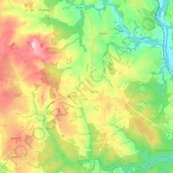
Name: Kinlet topographic map, elevation, terrain.
Location: Kinlet, Shropshire, England, United Kingdom (52.38151 -2.44690 52.45071 -2.33359)
Average elevation: 387 ft
Minimum elevation: 72 ft
Maximum elevation: 755 ft
Other topographic maps
Click on a map to view its topography, its elevation and its terrain.
Minton
United Kingdom > England > Shropshire > Church Stretton > Little Stretton
Average elevation: 892 ft
Cothercott Hill
United Kingdom > England > Shropshire > Church Pulverbatch
Average elevation: 1,122 ft