
Town of Brigham topographic map
Interactive map
Click on the map to display elevation.
About this map
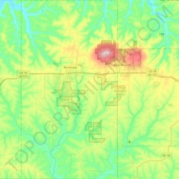
Name: Town of Brigham topographic map, elevation, terrain.
Average elevation: 1,083 ft
Minimum elevation: 755 ft
Maximum elevation: 1,719 ft
Other topographic maps
Click on a map to view its topography, its elevation and its terrain.
Jonesdale
United States > Wisconsin > Iowa County
Jonesdale, Town of Waldwick, Iowa County, Wisconsin, United States
Average elevation: 1,004 ft
Linden
United States > Wisconsin > Iowa County
Linden, Iowa County, Wisconsin, 53553, United States
Average elevation: 1,089 ft
Cobb
United States > Wisconsin > Iowa County
Cobb, Iowa County, Wisconsin, 53526, United States
Average elevation: 1,178 ft
Rewey
United States > Wisconsin > Iowa County
Rewey, Iowa County, Wisconsin, United States
Average elevation: 1,093 ft
Highland
United States > Wisconsin > Iowa County
Highland, Iowa County, Wisconsin, United States
Average elevation: 1,158 ft
Arena
United States > Wisconsin > Iowa County
Arena, Iowa County, Wisconsin, United States
Average elevation: 755 ft
Montfort Junction
United States > Wisconsin > Iowa County
Montfort Junction, Town of Eden, Iowa County, Wisconsin, 53569, United States
Average elevation: 1,168 ft
Edmund
United States > Wisconsin > Iowa County
Edmund, Town of Linden, Iowa County, Wisconsin, 53535, United States
Average elevation: 1,152 ft
Avoca
United States > Wisconsin > Iowa County
Avoca, Iowa County, Wisconsin, United States
Average elevation: 712 ft
Town of Mineral Point
United States > Wisconsin > Iowa County
Town of Mineral Point, Iowa County, Wisconsin, 53565, United States
Average elevation: 1,099 ft
Governor Dodge State Park
United States > Wisconsin > Iowa County
Governor Dodge State Park, Town of Dodgeville, Iowa County, Wisconsin, 53533, United States
Average elevation: 1,102 ft
Tower Hill State Park
United States > Wisconsin > Iowa County > Town of Wyoming
Tower Hill State Park, Town of Wyoming, Iowa County, Wisconsin, United States
Average elevation: 764 ft
Blue Mound State Park
United States > Wisconsin > Iowa County > Village of Blue Mounds
Blue Mound State Park, Village of Blue Mounds, Town of Brigham, Iowa County, Wisconsin, 53517, United States
Average elevation: 1,365 ft
Town of Wyoming
United States > Wisconsin > Iowa County
Town of Wyoming, Iowa County, Wisconsin, United States
Average elevation: 876 ft
Ridgeway
United States > Wisconsin > Iowa County
Ridgeway, Iowa County, Wisconsin, United States
Average elevation: 1,109 ft
Town of Moscow
United States > Wisconsin > Iowa County
Town of Moscow, Iowa County, Wisconsin, 53544, United States
Average elevation: 961 ft
Mineral Point
United States > Wisconsin > Iowa County
Mineral Point, Iowa County, Wisconsin, United States
Average elevation: 1,063 ft
Blue Mounds
United States > Wisconsin > Iowa County
Blue Mounds, Town of Brigham, Iowa County, Wisconsin, 53517, United States
Average elevation: 1,368 ft
Barneveld
United States > Wisconsin > Iowa County
Barneveld, Iowa County, Wisconsin, United States
Average elevation: 1,148 ft
Dodgeville
United States > Wisconsin > Iowa County
Dodgeville, Iowa County, Wisconsin, United States
Average elevation: 1,211 ft
Hollandale
United States > Wisconsin > Iowa County
Hollandale, Iowa County, Wisconsin, United States
Average elevation: 912 ft