Geolocate

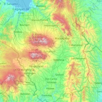
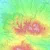
Bukidnon topographic map

Click on the map to display elevation.

Bukidnon

Situated within Bukidnon is Mount Dulang-dulang, the 2nd highest mountain in the country, with an elevation of 2,938 metres (9,639 ft) located in the Kitanglad Mountain Range. Mount Kitanglad (2,899 m), Mount Kalatungan (2,860 m), Mount Maagnaw (2,742 m), Mount Lumuluyaw (2,612 m), and Mount Tuminungan (2,400 m), the 4th, 5th, 8th, 17th, and 30th highest mountains in the country respectively, are also found in the province.

Wikipedia (CC-BY-SA 3.0)

About this map

Name: Bukidnon topographic map, elevation, terrain.

Location: Bukidnon, Northern Mindanao, Philippines (7.40326 124.55244 8.60158 125.44932)

Average elevation: 2,251 ft

Minimum elevation: -7 ft

Maximum elevation: 9,380 ft

Other topographic maps

Click on a map to view its topography, its elevation and its terrain.
Baguio

Philippines

In 1903, Filipinos, Japanese and Chinese workers were hired to build Kennon Road, the first road directly connecting Baguio with the lowlands of La Union and Pangasinan. Before this, the only road to Benguet was Naguilian Road, and it was largely a horse trail at higher elevations. Camp John Hay was…

Average elevation: 2,890 ft
Tarlac City

Philippines > Tarlac

Average elevation: 184 ft

Cebu City

Philippines > Cebu > Cebu City

Average elevation: 459 ft

Quezon City

Philippines

Founded as a pueblo by Saint Pedro Bautista in 1590, San Francisco del Monte may be considered Quezon City's oldest district. The original land area of the old town of San Francisco del Monte was approximately2.5 square kilometres (1.0 sq mi) and covered parts of what is currently known as Project 7 and 8 and…

Average elevation: 187 ft
Upper Agno River Basin

Philippines > Benguet

Average elevation: 4,229 ft

Meycauayan

Philippines > Bulacan

Average elevation: 89 ft

Santa Rosa

Philippines > Laguna > Santa Rosa

Average elevation: 213 ft

Dagupan

Philippines > Pangasinan

Average elevation: 39 ft

Parañaque

Philippines

Average elevation: 46 ft

Bohol

Philippines

Average elevation: 381 ft

Mount Pulag

Philippines > Benguet

At lower elevations, Mount Pulag has a mossy forest full of ferns, lichens, and moss.

Average elevation: 8,438 ft
Tayabas

Philippines > Quezon

Average elevation: 807 ft

Bacoor

Philippines > Cavite

Average elevation: 59 ft

Iligan

Philippines

Average elevation: 751 ft

Iba O'Este

Philippines > Bulacan > Calumpit

Average elevation: 13 ft

Candaba

Philippines

Average elevation: 20 ft

Lingayen

Philippines > Pangasinan

Average elevation: 13 ft

Balingasag

Philippines > Misamis Oriental

Average elevation: 98 ft

Echague

Philippines > Isabela

Average elevation: 233 ft

El Nido

Philippines > Palawan

Average elevation: 108 ft

Pasig

Philippines

Average elevation: 151 ft

Davao Gulf

Philippines

Average elevation: 0 ft

La Mesa Dam

Philippines > Quezon City

The La Mesa was built in Novaliches, which was then still part of the municipality of Caloocan due to the sloping topography of the watershed area from Bulacan. The La Mesa dam later became part of a larger dam system with the opening of the Ipo Dam in Norzagaray, Bulacan in 1936, the Angat Dam in the same…

Average elevation: 213 ft
Albay

Philippines

Average elevation: 157 ft

Legazpi

Philippines > Albay

Legazpi's topography is generally plain on the northeastern areas, with slopes ranging from five to fifteen degrees. The southern areas have mostly rolling to hilly terrain. In the city's coastal areas, the terrain varies from plain (north) to hilly (south). Legazpi is criss-crossed by several rivers including…

Average elevation: 492 ft
Alabel

Philippines > Sarangani

Average elevation: 207 ft

Camiguin Island

Philippines > Camiguin

Average elevation: 167 ft

Navotas

Philippines > Navotas

Average elevation: 52 ft

Tucdao

Philippines > Biliran

Average elevation: 180 ft

Monkayo

Philippines > Davao de Oro

Average elevation: 282 ft

Bambang

Philippines > Nueva Vizcaya

Average elevation: 1,234 ft

Botolan

Philippines > Zambales

Average elevation: 72 ft

Jose Panganiban

Philippines > Camarines Norte

Average elevation: 135 ft

Kabayan

Philippines > Benguet

Average elevation: 5,177 ft

Nueva Ecija

Philippines

Average elevation: 367 ft

Guiguinto

Philippines > Bulacan

Average elevation: 16 ft

Valencia

Philippines > Negros Oriental > Valencia

Valencia occupies an area of 14,749 hectares (36,450 acres), 35% of which are classified as plains. The town is 65% mountainous, with elevation averaging from 200 to 500 metres (660 to 1,640 ft) above sea level, with the top of Mount Talinis at an elevation of 1,903 metres (6,243 ft) along the municipal…

Average elevation: 820 ft
Panglao Island

Philippines > Bohol

Average elevation: 154 ft

San Ildefonso

Philippines > Bulacan

Average elevation: 56 ft

Pili

Philippines > Camarines Sur

Average elevation: 102 ft

Alicia

Philippines > Isabela

Average elevation: 220 ft

Ramon

Philippines > Isabela

Average elevation: 328 ft

Valencia

Philippines > Bukidnon

The city's topography is characterized as flat to undulating hills with extensive plateaus and mountainous areas and cliffs on both eastern and western portions bounding the municipality of San Fernando on the east and the municipality of Talakag on the west. Its highest point is Mount Kalatungan in the…

Average elevation: 1,857 ft
Initao

Philippines > Misamis Oriental

Average elevation: 138 ft

Camalig

Philippines > Albay

Average elevation: 627 ft

Pagadian

Philippines > Zamboanga del Sur

About 45% of the total city area is steeply sloping terrain of hills and mountains on the northwestern portion that covers an estimated 15,090 hectares. Mt. Sugarloaf (1,376 m.), Mt. Pinukis (1,213 m.), and Mt. Palpalan (650 m.) are the three notable mountain peaks. Areas in the direct north and central part,…

Average elevation: 554 ft
San Fernando

Philippines > Pampanga

Average elevation: 79 ft

Cadlan

Philippines > Camarines Sur > Pili

Average elevation: 131 ft

Aurora Hill North Central

Philippines

Average elevation: 4,852 ft

Santa Cruz

Philippines > Tarlac > Tarlac City

Average elevation: 121 ft

Carmen

Philippines > Cagayan de Oro

Average elevation: 105 ft

Samar

Philippines

Average elevation: 125 ft

Bulacan

Philippines

Average elevation: 344 ft

Esperanza Ibaba

Philippines > Cavite > Alfonso

Average elevation: 1,506 ft

Cavinti

Philippines > Laguna > Cavinti

Average elevation: 820 ft

Nabua

Philippines > Camarines Sur > Nabua

Nabua has about 8,803.0600 hectares or 99.42% very low elevation or less than 100 meters elevation and remaining 51.3593 hectares or 0.58% of low elevation or between 100 and 300 meters elevation. Its slope covers about 7,927.3616 hectares or 89.53% which are level to nearly level (0-3%) while the remaining…

Average elevation: 46 ft
Olongapo

Philippines > Zambales > Olongapo

Average elevation: 636 ft

Sorsogon City

Philippines > Sorsogon

Sorsogon City covers a land area of 31,292 hectares (120.82 sq mi). It is at the southernmost tip of the Bicol Peninsula and of Luzon Island. The city is bounded by Castilla in the west, Manito in the northwest, Albay Gulf in the north, Prieto Diaz in the east, Gubat in the southeast, Casiguran in the…

Average elevation: 295 ft
Mandaluyong

Philippines

Another claims that the Spaniards named the place based on the report of a navigator named Acapulco, who saw the rolling hills frequently being lashed at by daluyong (“big waves from the sea”). This seems to confirm traditional pre-Hispanic stories that giant waves from the sea would meet the adjoining…

Average elevation: 108 ft

Marikina

Philippines

Average elevation: 262 ft

Ilayang Taykin

Philippines > Laguna > Liliw

Average elevation: 886 ft

Basac

Philippines > Bukidnon > Lantapan

Average elevation: 3,858 ft

Malasag Hill

Philippines > Cagayan de Oro

Average elevation: 515 ft

Sinocalan River

Philippines > Pangasinan > Santa Barbara

Average elevation: 20 ft

Navotas River

Philippines > Navotas

Average elevation: 16 ft

Tiwi

Philippines > Albay

Average elevation: 144 ft

Dalig

Philippines > Rizal > Teresa

Average elevation: 240 ft

Catmon

Philippines > Bulacan > Santa Maria

Average elevation: 102 ft

Loboc River

Philippines > Bohol > Loboc > Camisan

Average elevation: 230 ft

Banjo Laurel

Philippines > Batangas > Tanauan

Average elevation: 548 ft

Cabalawan

Philippines > Tacloban > Cabalawan

Average elevation: 85 ft

Mount Three Peaks

Philippines > Cebu > Altavista

Average elevation: 787 ft

Nueva Vizcaya

Philippines

Average elevation: 351 ft

Ambiong

Philippines > Benguet > La Trinidad

Average elevation: 4,856 ft

Alobo

Philippines > Albay > Daraga

Average elevation: 308 ft

Lebak

Philippines > Sultan Kudarat

Average elevation: 62 ft

Quirino

Philippines

Average elevation: 354 ft

Tatala

Philippines > Rizal > Binangonan

Average elevation: 171 ft

Pundaquit

Philippines > Zambales > San Antonio

Average elevation: 259 ft

Romblon Island

Philippines > Romblon

Average elevation: 141 ft

Naval

Philippines > Biliran

Average elevation: 102 ft

Cabatuan

Philippines > Iloilo

Average elevation: 243 ft

San Miguel

Philippines > Bulacan

Average elevation: 72 ft

Murcia

Philippines > Negros Occidental > Murcia

Average elevation: 413 ft

Tanay

Philippines > Rizal

Average elevation: 105 ft

Montalban

Philippines > Rizal > Rodriguez

Rodriguez is generally very rough in topography, with 83% of its total land area composed of upland areas, hills and mountain ranges. The remaining 17% low-lying terrain and rolling lands are found at the south-western portion of the municipality, along with the northern portions of the Municipality of San…

Average elevation: 325 ft
Guimba

Philippines > Nueva Ecija

Average elevation: 115 ft

Palo

Philippines > Leyte > Palo

Average elevation: 36 ft

Marawi

Philippines > Lanao del Sur

Marawi is located upon the shores of Lake Lanao.[6] It is primarily inhabited by the Maranao people. The city is also called the "summer capital of the south" due to its higher elevation and cooler climate,[7] a nickname it shares with Malaybalay.[8][better source needed]

Average elevation: 2,320 ft
San Juan

Philippines

"San Juan" is a contraction of the city's traditional name of "San Juan del Monte" (lit. 'Saint John of the Mountain'). As with numerous other places in the Philippines, the name combines a patron saint and a toponym; in this case Saint John the Baptist with the locale's hilly terrain and relatively higher…

Average elevation: 115 ft

Kalanganan 1

Philippines > Cotabato City

Average elevation: 16 ft

Culaba

Philippines > Biliran

Average elevation: 407 ft

Bulan

Philippines > Sorsogon

Average elevation: 16 ft

Datu Montawal

Philippines > Maguindanao del Sur

Average elevation: 46 ft

Duka

Philippines > Misamis Oriental

Average elevation: 167 ft

Jiabong

Philippines > Samar

Average elevation: 157 ft

Mondragon

Philippines > Northern Samar

Average elevation: 43 ft

Gear up for your next adventure:

⛑️Personal Locator Beacon - Safety beacon for emergencies
🛌Ultralight Sleeping Bags - Compact down bags for cold nights in the wilderness
🔋Rechargeable Batteries - Power up your outdoor devices
🪓Survival Multi‑Tool - Versatile tool for camp and trail tasks
🧦Hiking Socks - Comfortable socks to prevent blisters on long hikes

As an Amazon Associate, this site earns from qualifying purchases at no extra cost to you.