
Make a donation
Gear up for your next adventure:
As an Amazon Associate, this site earns from qualifying purchases at no extra cost to you.
Todd Creek topographic map
Click on the map to display elevation.
Make a donation
Gear up for your next adventure:
As an Amazon Associate, this site earns from qualifying purchases at no extra cost to you.
About this map
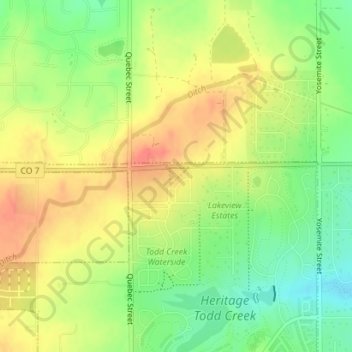
Name: Todd Creek topographic map, elevation, terrain.
Location: Todd Creek, Adams County, Colorado, United States (39.98506 -104.89931 39.98646 -104.89740)
Average elevation: 5,144 ft
Minimum elevation: 5,052 ft
Maximum elevation: 5,223 ft
Adams County trails, hiking, mountain biking, running and outdoor activities
Make a donation
Gear up for your next adventure:
As an Amazon Associate, this site earns from qualifying purchases at no extra cost to you.
Other topographic maps
Click on a map to view its topography, its elevation and its terrain.
Make a donation
Gear up for your next adventure:
As an Amazon Associate, this site earns from qualifying purchases at no extra cost to you.
Rocky Mountain Arsenal National Wildlife Refuge
United States > Colorado > Adams County
Average elevation: 5,223 ft
Make a donation
Gear up for your next adventure:
As an Amazon Associate, this site earns from qualifying purchases at no extra cost to you.
Westminster
United States > Colorado > Adams County > Westminster > Westminster
Average elevation: 5,446 ft