Geolocate

Brighton topographic map

Click on the map to display elevation.

About this map

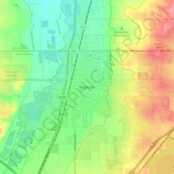
Name: Brighton topographic map, elevation, terrain.

Location: Brighton, Adams County, Colorado, 80601, United States (39.94372 -104.85108 40.02372 -104.77108)

Average elevation: 5,030 ft

Minimum elevation: 4,911 ft

Maximum elevation: 5,190 ft

Adams County trails, hiking, mountain biking, running and outdoor activities

Other topographic maps

Click on a map to view its topography, its elevation and its terrain.

Barr Lake

United States > Colorado > Adams County

Average elevation: 5,102 ft

Bennett

United States > Colorado > Adams County

Average elevation: 5,551 ft

Todd Creek

United States > Colorado > Adams County

Average elevation: 5,144 ft

Welby

United States > Colorado > Adams County > Welby

Average elevation: 5,167 ft

Berkley

United States > Colorado > Adams County > Berkley

Average elevation: 5,236 ft

Sand Creek Park

United States > Colorado > Adams County > Aurora

Average elevation: 5,344 ft

Federal Heights

United States > Colorado > Adams County

Average elevation: 5,463 ft

Gear up for your next adventure:

📖Nature Tracking Books - Learn to track wildlife and terrain
🛰️Handheld GPS Units - Professional satellite navigators for precise backcountry mapping
🦶Hiking Gaiters - Keep debris and water out of your boots
🪶LED Camping Lantern - Bright lantern for camp lighting
🪶Fire Starter Kit - Reliable fire starter for survival and camping

As an Amazon Associate, this site earns from qualifying purchases at no extra cost to you.