Geolocate

Austin topographic map

Interactive map

Click on the map to display elevation.

Austin

The elevation of Austin varies from 425 feet (130 m) to approximately 1,000 feet (305 m) above sea level. Due to the fact it straddles the Balcones Fault, much of the eastern part of the city is flat, with heavy clay and loam soils, whereas the western part and western suburbs consist of rolling hills on the edge of the Texas Hill Country. Because the hills to the west are primarily limestone rock with a thin covering of topsoil, portions of the city are frequently subjected to flash floods from the runoff caused by thunderstorms. To help control this runoff and to generate hydroelectric power, the Lower Colorado River Authority operates a series of dams that form the Texas Highland Lakes. The lakes also provide venues for boating, swimming, and other forms of recreation within several parks on the lake shores.

Wikipedia (CC-BY-SA 3.0)

About this map

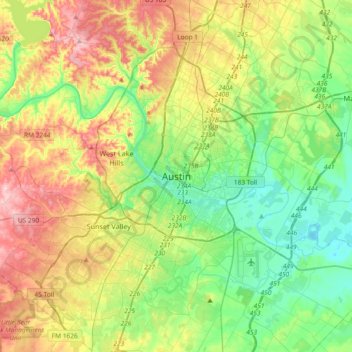
Name: Austin topographic map, elevation, terrain.

Location: Austin, Travis County, Texas, 78701, United States (30.11113 -97.90370 30.43113 -97.58370)

Average elevation: 666 ft

Minimum elevation: 387 ft

Maximum elevation: 1,148 ft

Travis County trails, hiking, mountain biking, running and outdoor activities

Other topographic maps

Click on a map to view its topography, its elevation and its terrain.

Lake Travis

United States > Texas > Travis County > Lago Vista

Average elevation: 912 ft

Point Venture

United States > Texas > Travis County

Average elevation: 719 ft

Lake Austin

United States > Texas > Travis County > Austin

Average elevation: 794 ft

Hamilton Pool

United States > Texas > Travis County

Average elevation: 902 ft

Bee Cave

United States > Texas > Travis County

According to the United States Census Bureau in 2010, the city has a total area of 2.6 square miles (6.7 km2), all of it land. Prior to the 2010 census, Bee Cave went from being a village to being a city, increasing its area to 6.8 square miles (18 km2), all land. It borders Lakeway to the northwest. The…

Average elevation: 886 ft

Pace Bend Park

United States > Texas > Travis County

Average elevation: 735 ft

Lady Bird Lake

United States > Texas > Travis County > Austin

Average elevation: 561 ft

Mustang Ridge

United States > Texas > Travis County

Average elevation: 614 ft

Mayfield Park

United States > Texas > Travis County > Austin

Average elevation: 591 ft

Zilker Park

United States > Texas > Travis County > Austin

Average elevation: 512 ft

Boggy Creek

United States > Texas > Travis County > Austin

Average elevation: 568 ft

West Lake Hills

United States > Texas > Travis County

Average elevation: 751 ft

Colorado River

United States > Texas > Travis County > Austin

Average elevation: 689 ft

Shoal Creek

United States > Texas > Travis County > Austin

Average elevation: 781 ft

St. Edwards Park

United States > Texas > Travis County

Average elevation: 830 ft

Walter E Long Lake

United States > Texas > Travis County > Austin

Average elevation: 577 ft

Manor

United States > Texas > Travis County

Average elevation: 561 ft

Rollingwood

United States > Texas > Travis County

Average elevation: 577 ft

Walnut Creek

United States > Texas > Travis County > Austin

Average elevation: 640 ft

Onion Creek

United States > Texas > Travis County > Austin

Average elevation: 535 ft

Briarcliff

United States > Texas > Travis County

Average elevation: 833 ft

Volente

United States > Texas > Travis County > Volente

Average elevation: 817 ft

Creedmoor

United States > Texas > Travis County > Creedmoor

Average elevation: 663 ft

Webberville

United States > Texas > Travis County

Average elevation: 410 ft

Wells Branch

United States > Texas > Travis County

Average elevation: 823 ft