Geolocate

Davidson topographic map

Click on the map to display elevation.

About this map

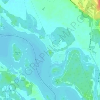
Name: Davidson topographic map, elevation, terrain.

Location: Davidson, Mansfield-et-Pontefract, Pontiac, Outaouais, Quebec, J0X 1V0, Canada (45.84952 -76.78764 45.88952 -76.74764)

Average elevation: 367 ft

Minimum elevation: 341 ft

Maximum elevation: 525 ft

Other topographic maps

Click on a map to view its topography, its elevation and its terrain.

Otter Lake

Canada > Quebec > Pontiac

Average elevation: 860 ft

Shawville

Canada > Quebec > Pontiac

Average elevation: 558 ft

Lac Rueckwald

Canada > Quebec > Pontiac > Thorne

Average elevation: 732 ft

Bryson

Canada > Quebec > Pontiac

Average elevation: 459 ft

Lac Pomponne

Canada > Quebec > Pontiac > Lac-Nilgaut

Average elevation: 1,138 ft

Lac Gerta

Canada > Quebec > Pontiac > Otter Lake

Average elevation: 879 ft

Lac d'Ours

Canada > Quebec > Pontiac > Litchfield

Average elevation: 784 ft

Lac Vert

Canada > Quebec > Pontiac > Rapides-des-Joachims

Average elevation: 1,033 ft

Mansfield-et-Pontefract

Canada > Quebec > Pontiac

Average elevation: 781 ft

Shawville

Canada > Quebec > Pontiac

Average elevation: 561 ft

L'Isle-aux-Allumettes

Canada > Quebec > Pontiac

Average elevation: 486 ft

Bristol

Canada > Quebec > Pontiac

Average elevation: 459 ft

Lac Antiquois

Canada > Quebec > Pontiac > Lac-Nilgaut

Average elevation: 1,201 ft

Lac Sopwith

Canada > Quebec > Pontiac > Otter Lake

Average elevation: 902 ft

Zec Saint-Patrice

Canada > Quebec > Pontiac

Average elevation: 974 ft

Portage-du-Fort

Canada > Quebec > Pontiac

Average elevation: 338 ft

Lac-Nilgaut

Canada > Quebec > Pontiac

The eponymous Lake Nilgaut is located roughly in the centre of the territory, at an altitude of over 300 metres (980 ft). This 9 kilometres (5.6 mi) long lake is named after the nilgai (French: nilgaut), the largest Asian antelope and only found on the Indian subcontinent. The name was officially introduced in…

Average elevation: 1,129 ft

Lac Bongard

Canada > Quebec > Pontiac > Rapides-des-Joachims

Average elevation: 1,053 ft

Waltham

Canada > Quebec > Pontiac

Its territory, with a maximum elevation of just over 350 metres (1,150 ft), is sparsely populated, the majority of the population living along or near the Ottawa River. The northern portion is a vast extended tract of undeveloped land, dotted with lakes, such as Findlay, Landon, Gagnon, and Caughlin, which are…

Average elevation: 804 ft

Campbell's Bay

Canada > Quebec > Pontiac

Average elevation: 420 ft

ZEC Rapides-des-Joachims

Canada > Quebec > Pontiac

Average elevation: 1,070 ft

Fort-Coulonge

Canada > Quebec > Pontiac

Average elevation: 371 ft

Clarendon

Canada > Quebec > Pontiac

Average elevation: 499 ft

Campbell's Bay

Canada > Quebec > Pontiac

Average elevation: 420 ft

Thorne

Canada > Quebec > Pontiac

Average elevation: 728 ft

Lac a la Truite

Canada > Quebec > Pontiac > Sheenboro

Average elevation: 889 ft

L'Isle-aux-Allumettes

Canada > Quebec > Pontiac

Average elevation: 486 ft

Gear up for your next adventure:

🏥Hiking First Aid Kits - Comprehensive medical kits for remote trail injuries
🔊Portable Camp Speaker - Music and alerts at camp
🖼️Topo Map Wall Art - Decorative topographic prints of famous peaks and regions
🕶️Glacier Sunglasses - Side shields to protect eyes from high-altitude snow glare
👟Trail Running Shoes - Lightweight shoes for trail runners

As an Amazon Associate, this site earns from qualifying purchases at no extra cost to you.