
Stroud topographic map
Click on the map to display elevation.
About this map
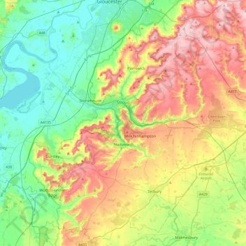
Name: Stroud topographic map, elevation, terrain.
Location: Stroud, Gloucestershire, England, United Kingdom (51.58984 -2.54081 51.85046 -2.06871)
Average elevation: 371 ft
Minimum elevation: 0 ft
Maximum elevation: 991 ft
Other topographic maps
Click on a map to view its topography, its elevation and its terrain.
Sudeley Castle
United Kingdom > England > Gloucestershire > Cheltenham > Sudeley
His elevation almost certainly came from his assistance in the suppression of the Wyatt rebellion.
Average elevation: 443 ft
Five Acres
United Kingdom > England > Gloucestershire > Forest of Dean > Berry Hill
Average elevation: 640 ft
Aquaventure
United Kingdom > England > Gloucestershire > Cotswold District > Somerford Keynes > Shorncote
Average elevation: 302 ft
Bishop's Cleeve
United Kingdom > England > Gloucestershire > Tewkesbury > Gotherington
Average elevation: 167 ft
Cinderford Skate Park
United Kingdom > England > Gloucestershire > Forest of Dean District > Cinderford
Average elevation: 650 ft
Hardwicke Green
United Kingdom > England > Gloucestershire > Stroud > Hardwicke
Average elevation: 69 ft
Broad Campden
United Kingdom > England > Gloucestershire > Cotswold District
Average elevation: 548 ft
Broadwell
United Kingdom > England > Gloucestershire > Forest of Dean > Broadwell
Average elevation: 604 ft
Beachley
United Kingdom > England > Gloucestershire > Forest of Dean District
Average elevation: 43 ft
Whitminster
United Kingdom > England > Gloucestershire > Stroud > Whitminster
Average elevation: 69 ft