
Make a donation
Gear up for your next adventure:
As an Amazon Associate, this site earns from qualifying purchases at no extra cost to you.
Jamesburg topographic map
Click on the map to display elevation.
Make a donation
Gear up for your next adventure:
As an Amazon Associate, this site earns from qualifying purchases at no extra cost to you.
About this map
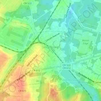
Name: Jamesburg topographic map, elevation, terrain.
Location: Jamesburg, Middlesex County, New Jersey, United States (40.34226 -74.45406 40.36107 -74.42316)
Average elevation: 82 ft
Minimum elevation: 23 ft
Maximum elevation: 161 ft
Make a donation
Gear up for your next adventure:
As an Amazon Associate, this site earns from qualifying purchases at no extra cost to you.
Other topographic maps
Click on a map to view its topography, its elevation and its terrain.
North Stelton
United States > New Jersey > Middlesex County > Piscataway Township
Average elevation: 95 ft
Frost Woods Park
United States > New Jersey > Middlesex County > East Brunswick Township
Average elevation: 95 ft
Make a donation
Gear up for your next adventure:
As an Amazon Associate, this site earns from qualifying purchases at no extra cost to you.
Middlesex Downs
United States > New Jersey > Middlesex County > Monroe Township
Average elevation: 108 ft
Make a donation
Gear up for your next adventure:
As an Amazon Associate, this site earns from qualifying purchases at no extra cost to you.
Elmer B Boyd Park
United States > New Jersey > Middlesex County > New Brunswick > Feaster Park
Average elevation: 72 ft
Make a donation
Gear up for your next adventure:
As an Amazon Associate, this site earns from qualifying purchases at no extra cost to you.
Possumtown
United States > New Jersey > Middlesex County > Piscataway Township
Average elevation: 62 ft
Lawrence Brook Manor
United States > New Jersey > Middlesex County > East Brunswick Township
Average elevation: 62 ft
Randolphville
United States > New Jersey > Middlesex County > Piscataway Township
Average elevation: 85 ft
Paulas Corners
United States > New Jersey > Middlesex County > East Brunswick Township
Average elevation: 95 ft
Make a donation
Gear up for your next adventure:
As an Amazon Associate, this site earns from qualifying purchases at no extra cost to you.
Ten Mile Run
United States > New Jersey > Middlesex County > South Brunswick
Average elevation: 217 ft
Randolphville
United States > New Jersey > Middlesex County > Piscataway Township
Average elevation: 85 ft
Woodbridge
United States > New Jersey > Middlesex County > Woodbridge Township
Average elevation: 52 ft
North Stelton
United States > New Jersey > Middlesex County > Piscataway Township
Average elevation: 95 ft
Make a donation
Gear up for your next adventure:
As an Amazon Associate, this site earns from qualifying purchases at no extra cost to you.
Fieldville
United States > New Jersey > Middlesex County > Piscataway Township
Average elevation: 56 ft
Make a donation
Gear up for your next adventure:
As an Amazon Associate, this site earns from qualifying purchases at no extra cost to you.
Sand Hills
United States > New Jersey > Middlesex County > Woodbridge Township > Fords
Average elevation: 79 ft
Make a donation
Gear up for your next adventure:
As an Amazon Associate, this site earns from qualifying purchases at no extra cost to you.
Make a donation
Gear up for your next adventure:
As an Amazon Associate, this site earns from qualifying purchases at no extra cost to you.
Prospect Plains
United States > New Jersey > Middlesex County > Monroe Township
Average elevation: 128 ft
Berdines Corners
United States > New Jersey > Middlesex County > North Brunswick
Average elevation: 95 ft
Make a donation
Gear up for your next adventure:
As an Amazon Associate, this site earns from qualifying purchases at no extra cost to you.
Lynn Woodoaks
United States > New Jersey > Middlesex County > Woodbridge Township > Colonia
Average elevation: 102 ft
Make a donation
Gear up for your next adventure:
As an Amazon Associate, this site earns from qualifying purchases at no extra cost to you.
South River
United States > New Jersey > Middlesex County > South River > South River
Average elevation: 62 ft
Highland Park
United States > New Jersey > Middlesex County > Highland Park > Highland Park
Average elevation: 79 ft
Make a donation
Gear up for your next adventure:
As an Amazon Associate, this site earns from qualifying purchases at no extra cost to you.
New Market
United States > New Jersey > Middlesex County > Piscataway Township
Average elevation: 75 ft
Fairview Knolls
United States > New Jersey > Middlesex County > East Brunswick Township
Average elevation: 102 ft