Geolocate

Lequire topographic map

Click on the map to display elevation.

About this map

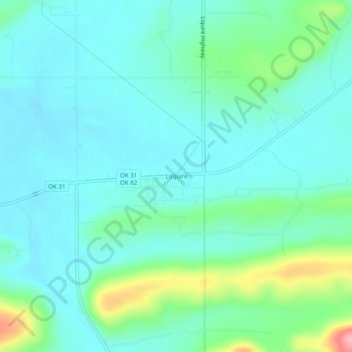
Name: Lequire topographic map, elevation, terrain.

Location: Lequire, Haskell County, Oklahoma, 74943, United States (35.08454 -95.12746 35.12454 -95.08746)

Average elevation: 607 ft

Minimum elevation: 515 ft

Maximum elevation: 951 ft

Haskell County trails, hiking, mountain biking, running and outdoor activities

Other topographic maps

Click on a map to view its topography, its elevation and its terrain.

Tamaha

United States > Oklahoma > Haskell County

Average elevation: 482 ft

Whitefield

United States > Oklahoma > Haskell County

Average elevation: 531 ft

McCurtain

United States > Oklahoma > Haskell County

Average elevation: 587 ft

Keota

United States > Oklahoma > Haskell County

Average elevation: 489 ft

Kinta

United States > Oklahoma > Haskell County

Average elevation: 564 ft

Stigler

United States > Oklahoma > Haskell County

Average elevation: 577 ft

Gear up for your next adventure:

📱Solar Portable Charger - Solar power bank for charging devices off‑grid
🧼Biodegradable Camping Soap - Eco‑friendly soap for outdoor hygiene
Solar GPS Watches - Advanced multisport watches with built-in topographic maps
🧷Carabiner Set - Durable clips for gear attachment
🪶Thermal Camp Blanket - Extra warmth for cold nights

As an Amazon Associate, this site earns from qualifying purchases at no extra cost to you.