Geolocate
👉 Easily get elevation data in JSON, GeoTIFF and KML formats using Elevation API
Thank you for supporting this site ❤️
Make a donation

Stigler topographic map

Click on the map to display elevation.

About this map

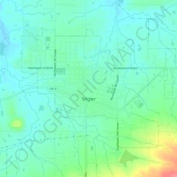
Name: Stigler topographic map, elevation, terrain.

Location: Stigler, Haskell County, Oklahoma, 74462, United States (35.24252 -95.14193 35.26958 -95.09240)

Average elevation: 577 ft

Minimum elevation: 515 ft

Maximum elevation: 771 ft

Haskell County trails, hiking, mountain biking, running and outdoor activities

Other topographic maps

Click on a map to view its topography, its elevation and its terrain.

Hoyt

United States > Oklahoma > Haskell County

Average elevation: 558 ft

Enterprise

United States > Oklahoma > Haskell County

Average elevation: 702 ft

Lequire

United States > Oklahoma > Haskell County

Average elevation: 607 ft

Brooken Mountain

United States > Oklahoma > Haskell County

Average elevation: 820 ft

Gear up for your next adventure:

👟Trail Running Shoes - Lightweight shoes for trail runners
🥾Women's Hiking Boots - Top-rated trail boots with ankle support and superior grip
📚USA Hiking Guide Books - Top trail guides and map books
🧺Microfiber Travel Towels - Compact and fast-drying towels for trail use
📡Handheld GPS Device - Reliable handheld GPS for outdoor navigation

As an Amazon Associate, this site earns from qualifying purchases at no extra cost to you.