
Make a donation
Gear up for your next adventure:
As an Amazon Associate, this site earns from qualifying purchases at no extra cost to you.
Villa de Ramos topographic map
Click on the map to display elevation.
Make a donation
Gear up for your next adventure:
As an Amazon Associate, this site earns from qualifying purchases at no extra cost to you.
About this map
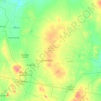
Name: Villa de Ramos topographic map, elevation, terrain.
Location: Villa de Ramos, San Luis Potosi, Mexico (22.65041 -102.26005 23.15832 -101.44627)
Average elevation: 6,864 ft
Minimum elevation: 6,309 ft
Maximum elevation: 8,527 ft
Make a donation
Gear up for your next adventure:
As an Amazon Associate, this site earns from qualifying purchases at no extra cost to you.
Other topographic maps
Click on a map to view its topography, its elevation and its terrain.
Parque Estatal Manantial de la Media Luna
Mexico > San Luis Potosi > Rioverde
Average elevation: 3,301 ft
Real de Catorce
Mexico > San Luis Potosi > Catorce
Although in the southern range of the Chihuahuan desert, due to its elevation, Real can be very cool at night. Although days, particularly in summer, can be very hot, it is advised to always bring a jacket, even in summer.
Average elevation: 8,763 ft
Make a donation
Gear up for your next adventure:
As an Amazon Associate, this site earns from qualifying purchases at no extra cost to you.
Make a donation
Gear up for your next adventure:
As an Amazon Associate, this site earns from qualifying purchases at no extra cost to you.
Make a donation
Gear up for your next adventure:
As an Amazon Associate, this site earns from qualifying purchases at no extra cost to you.
Make a donation
Gear up for your next adventure:
As an Amazon Associate, this site earns from qualifying purchases at no extra cost to you.