
Yigo Municipality topographic map
Interactive map
Click on the map to display elevation.
About this map
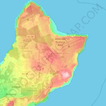
Name: Yigo Municipality topographic map, elevation, terrain.
Location: Yigo Municipality, Guam, United States (13.48595 144.85977 13.65438 144.95689)
Average elevation: 230 ft
Minimum elevation: 0 ft
Maximum elevation: 823 ft
Other topographic maps
Click on a map to view its topography, its elevation and its terrain.
Talofofo
United States > Guam > Talo’fo’fo’ Municipality
Talofofo, Talo’fo’fo’ Municipality, Guam, United States
Average elevation: 203 ft
Guam
United States > Guam > Chalan Pago-Ordot Municipality
Guam, Chalan Pago-Ordot Municipality, Guam, United States
Average elevation: 85 ft
Dededo
United States > Guam > Dededo Municipality
Dededo, Dededo Municipality, Guam, United States
Average elevation: 325 ft
Tarzan Falls
United States > Guam > Yona Municipality
Tarzan Falls, Yona Municipality, Guam, 96915, United States
Average elevation: 371 ft
Mount Lamlam
United States > Guam > Hågat Municipality
Mount Lamlam, Hågat Municipality, Guam, 96916, United States
Average elevation: 732 ft
Inarajan River
United States > Guam > Inalåhan Municipality > Inalåhan
Inarajan River, Inalåhan, Inalåhan Municipality, Guam, 96917, United States
Average elevation: 98 ft
Tarague Beach
United States > Guam > Yigo Municipality
Tarague Beach, Yigo Municipality, Guam, United States
Average elevation: 180 ft
Mongmong-Toto-Maite Municipality
United States > Guam > Mongmong-Toto-Maite Municipality
Mongmong-Toto-Maite Municipality, Guam, United States
Average elevation: 98 ft
Tamuning
United States > Guam > Tamuning Municipality
Tamuning, Tamuning Municipality, Guam, United States
Average elevation: 75 ft
Mariana Islands
United States > Guam > Chalan Pago-Ordot Municipality
Mariana Islands, Chalan Pago-Ordot Municipality, Guam, United States
Average elevation: 0 ft
Toto
United States > Guam > Mongmong-Toto-Maite Municipality
Toto, Mongmong-Toto-Maite Municipality, Guam, United States
Average elevation: 148 ft
Agat
United States > Guam > Hågat Municipality > Agat
Agat, Hågat Municipality, Guam, 96928, United States
Average elevation: 135 ft
Hagåtña
United States > Guam > Sinajana Municipality > Hagåtña
Hagåtña, Sinajana Municipality, Guam, United States
Average elevation: 92 ft