
Make a donation
Gear up for your next adventure:
As an Amazon Associate, this site earns from qualifying purchases at no extra cost to you.
City of Peekskill topographic map
Click on the map to display elevation.
Make a donation
Gear up for your next adventure:
As an Amazon Associate, this site earns from qualifying purchases at no extra cost to you.
About this map
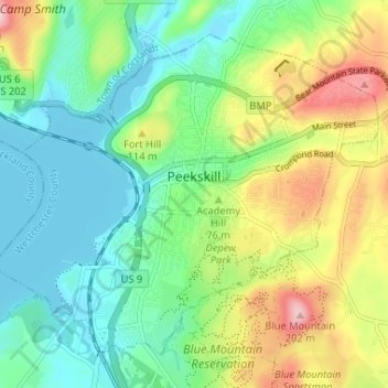
Name: City of Peekskill topographic map, elevation, terrain.
Average elevation: 220 ft
Minimum elevation: 0 ft
Maximum elevation: 656 ft
Westchester County trails, hiking, mountain biking, running and outdoor activities
Make a donation
Gear up for your next adventure:
As an Amazon Associate, this site earns from qualifying purchases at no extra cost to you.
Other topographic maps
Click on a map to view its topography, its elevation and its terrain.
Mount Hope
United States > New York > Westchester County > Village of Hastings-on-Hudson
Average elevation: 197 ft
Pleasantside
United States > New York > Westchester County > Town of Cortlandt
Average elevation: 354 ft
Mariandale
United States > New York > Westchester County > Village of Ossining
Average elevation: 174 ft
Make a donation
Gear up for your next adventure:
As an Amazon Associate, this site earns from qualifying purchases at no extra cost to you.
Sunset Ridge
United States > New York > Westchester County > Town/Village of Harrison
Average elevation: 89 ft
Make a donation
Gear up for your next adventure:
As an Amazon Associate, this site earns from qualifying purchases at no extra cost to you.
South Salem
United States > New York > Westchester County > Town of Lewisboro
Average elevation: 571 ft
Colonial Heights
United States > New York > Westchester County > City of Yonkers
Average elevation: 197 ft
Make a donation
Gear up for your next adventure:
As an Amazon Associate, this site earns from qualifying purchases at no extra cost to you.
Heath Ridge
United States > New York > Westchester County > Village of Scarsdale
Average elevation: 217 ft
Whitehall Corners
United States > New York > Westchester County > Town of Somers
Average elevation: 318 ft
Make a donation
Gear up for your next adventure:
As an Amazon Associate, this site earns from qualifying purchases at no extra cost to you.
Hawthorne
United States > New York > Westchester County > Town of Mount Pleasant
Average elevation: 390 ft
West Harrison
United States > New York > Westchester County > Town/Village of Harrison
Average elevation: 266 ft
Quarry Heights
United States > New York > Westchester County > Town/Village of Harrison
Average elevation: 367 ft
Make a donation
Gear up for your next adventure:
As an Amazon Associate, this site earns from qualifying purchases at no extra cost to you.
Purdys Grove
United States > New York > Westchester County > Village of Port Chester
Average elevation: 46 ft
Crotonville
United States > New York > Westchester County > Town of Ossining
Average elevation: 184 ft
Cedar Knolls
United States > New York > Westchester County > City of Yonkers
Average elevation: 187 ft
Sleepy Hollow Manor
United States > New York > Westchester County > Village of Sleepy Hollow
Average elevation: 135 ft
Make a donation
Gear up for your next adventure:
As an Amazon Associate, this site earns from qualifying purchases at no extra cost to you.
Cedar Knolls
United States > New York > Westchester County > City of Yonkers
Average elevation: 187 ft
Whitehall Corners
United States > New York > Westchester County > Town of Somers
Average elevation: 318 ft
Lake Lincolndale
United States > New York > Westchester County > Town of Somers > Shenorock
Average elevation: 531 ft
Make a donation
Gear up for your next adventure:
As an Amazon Associate, this site earns from qualifying purchases at no extra cost to you.
Murdock Woods
United States > New York > Westchester County > Town of Mamaroneck
Average elevation: 151 ft
Lake Katonah
United States > New York > Westchester County > Town of Lewisboro
Average elevation: 417 ft
Beechmont
United States > New York > Westchester County > City of New Rochelle
Average elevation: 102 ft
Turkey Mountain
United States > New York > Westchester County > Town of Yorktown
Average elevation: 466 ft
Make a donation
Gear up for your next adventure:
As an Amazon Associate, this site earns from qualifying purchases at no extra cost to you.
South Ridge
United States > New York > Westchester County > Village of Rye Brook
Average elevation: 121 ft
Mohegan Heights
United States > New York > Westchester County > City of Yonkers
Average elevation: 190 ft
Buckhout Corners
United States > New York > Westchester County > Village of Briarcliff Manor
Average elevation: 367 ft
Whitehall Corners
United States > New York > Westchester County > Town of Somers
Average elevation: 318 ft
Make a donation
Gear up for your next adventure:
As an Amazon Associate, this site earns from qualifying purchases at no extra cost to you.
Salem Center
United States > New York > Westchester County > Town of North Salem
Average elevation: 482 ft
Furnace Woods
United States > New York > Westchester County > Town of Cortlandt
Average elevation: 381 ft
Sun Haven
United States > New York > Westchester County > City of New Rochelle
Average elevation: 66 ft
Isle of San Souci
United States > New York > Westchester County > City of New Rochelle
Average elevation: 23 ft
Make a donation
Gear up for your next adventure:
As an Amazon Associate, this site earns from qualifying purchases at no extra cost to you.
Wykagyl Park
United States > New York > Westchester County > City of New Rochelle
Average elevation: 135 ft
Getty Square
United States > New York > Westchester County > City of Yonkers > Ludlow
Average elevation: 102 ft
Murray Hill
United States > New York > Westchester County > Village of Scarsdale
Average elevation: 259 ft
Van Cortlandtville
United States > New York > Westchester County > Town of Cortlandt
Average elevation: 262 ft
Make a donation
Gear up for your next adventure:
As an Amazon Associate, this site earns from qualifying purchases at no extra cost to you.
Park Hill
United States > New York > Westchester County > City of Yonkers > Park Hill
Average elevation: 141 ft
West Mount Vernon
United States > New York > Westchester County > City of Mount Vernon
Average elevation: 161 ft
Vista
United States > New York > Westchester County > Town of Lewisboro > Vista
Average elevation: 505 ft
Van Cortlandtville
United States > New York > Westchester County > Town of Cortlandt
Average elevation: 262 ft
Make a donation
Gear up for your next adventure:
As an Amazon Associate, this site earns from qualifying purchases at no extra cost to you.
Bedford Hills
United States > New York > Westchester County > Town of Bedford > Bedford Hills
Average elevation: 374 ft