
Pecatu topographic map
Click on the map to display elevation.
Pecatu
Pecatu is located in South Kuta District of the Badung Regency. It is at the western end of the Bukit Peninsula in south Bali, and has a hilly topography with limestone cliffs isolating small, short beaches that have been privately developed. Nusa Dua, on the opposite side of the peninsula, is flat and is a government-run resort with free access. Beaches at Pecatu have historically been popular with surfers and because of limited access, with nudists.
About this map
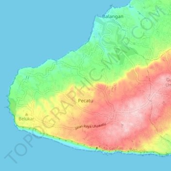
Name: Pecatu topographic map, elevation, terrain.
Location: Pecatu, Kuta Selatan, Bali, Indonesia (-8.84843 115.08383 -8.79324 115.15109)
Average elevation: 213 ft
Minimum elevation: 0 ft
Maximum elevation: 686 ft
Other topographic maps
Click on a map to view its topography, its elevation and its terrain.
CitraLand Waterpark Denpasar
Indonesia > Bali > Denpasar > Denpasar Barat > Padangsambian Kaja
Average elevation: 184 ft
Point of view on the lake and the mount Batur
Indonesia > Bali > Bangli > Songan B
Average elevation: 3,474 ft
Mount Agung
Indonesia > Bali > Karangasem
Australia's Bureau of Meteorology reported on 27 November that ash from the eruption had been observed at an altitude of 9,144 m. By the beginning of December, the eruption reduced to minor emissions of steam and smoke. On 12 December, a picture of the crater was taken showing a steadily growing lava dome…
Average elevation: 8,314 ft