Geolocate

Pila topographic map

Click on the map to display elevation.

Pila

There are more than 24 pistes (>70 km total length), including 4 blue runs, 29 red runs and 4 black runs, with a pipe zone and a slopestyle zone. There is one cable car, 3 gondolas, 8 chairlifts and 5 conveyors. The resort itself is at 1,814 metres altitude, while the highest skiing can be done at 2,700m.

Wikipedia (CC-BY-SA 3.0)

About this map

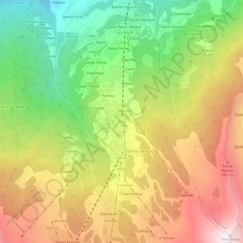
Name: Pila topographic map, elevation, terrain.

Location: Pila, Gressan, Aosta Valley, Italy (45.66727 7.29082 45.70727 7.33082)

Average elevation: 5,961 ft

Minimum elevation: 2,927 ft

Maximum elevation: 9,226 ft

Other topographic maps

Click on a map to view its topography, its elevation and its terrain.

Ollomont

Italy > Aosta Valley

Average elevation: 8,064 ft

Morgex

Italy > Aosta Valley

Average elevation: 5,965 ft

Saint-Rhémy-en-Bosses

Italy > Aosta Valley

Average elevation: 7,156 ft

Saint-Marcel

Italy > Aosta Valley

Average elevation: 6,437 ft

Paquier

Italy > Aosta Valley > Saint-Marcel

Average elevation: 2,356 ft

Ghiacciaio di Cherillon

Italy > Aosta Valley > Valtournenche

Average elevation: 10,351 ft

Saint-Denis

Italy > Aosta Valley

Average elevation: 3,556 ft

Torgnon

Italy > Aosta Valley

Average elevation: 6,440 ft

Castello Gamba

Italy > Aosta Valley > Châtillon > Sétoret

Average elevation: 2,254 ft

Monte Rosa Massif

Italy > Aosta Valley > Gressoney-La-Trinité

Average elevation: 11,411 ft

Pré-Saint-Didier

Italy > Aosta Valley

Average elevation: 5,889 ft

Lago di Place Moulin

Italy > Aosta Valley

Average elevation: 7,536 ft

Saint-Vincent

Italy > Aosta Valley

Saint-Vincent (Valdôtain: Sèn-Veuncein; Issime Walser: Finze) is a town and comune in the Aosta Valley region of north-western Italy. Saint-Vincent, elevation 575 metres (1,886 ft), is a popular summer holiday resort with mineral springs.

Average elevation: 3,868 ft

Gear up for your next adventure:

🧣Merino Neck Gaiters - Multi-functional headwear for wind and sun protection
Backpacking Tent - Lightweight and durable tent for multi‑day hikes
🧤Hiking Gloves - Protective gloves for rugged trails
🪶Trail Camera - Capture wildlife on your hikes
🗺️NatGeo Topo Maps - High-quality waterproof printed topographic maps of US Parks

As an Amazon Associate, this site earns from qualifying purchases at no extra cost to you.