Geolocate

Torgnon topographic map

Click on the map to display elevation.

About this map

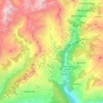
Name: Torgnon topographic map, elevation, terrain.

Location: Torgnon, Aosta Valley, Italy (45.76371 7.52457 45.88348 7.60334)

Average elevation: 6,440 ft

Minimum elevation: 2,192 ft

Maximum elevation: 11,463 ft

Other topographic maps

Click on a map to view its topography, its elevation and its terrain.

Monte Rosa Massif

Italy > Aosta Valley > Gressoney-La-Trinité

Average elevation: 11,411 ft

Pila

Italy > Aosta Valley

There are more than 24 pistes (>70 km total length), including 4 blue runs, 29 red runs and 4 black runs, with a pipe zone and a slopestyle zone. There is one cable car, 3 gondolas, 8 chairlifts and 5 conveyors. The resort itself is at 1,814 metres altitude, while the highest skiing can be done at 2,700m.

Average elevation: 5,961 ft

Entrèves

Italy > Aosta Valley > Courmayeur

Average elevation: 5,584 ft

Maen

Italy > Aosta Valley

Average elevation: 6,158 ft

Liex

Italy > Aosta Valley > Epaillon

Average elevation: 4,354 ft

Dégioz

Italy > Aosta Valley > Valsavarenche

Average elevation: 7,133 ft

Lago di Place Moulin

Italy > Aosta Valley

Average elevation: 7,536 ft

Evian

Italy > Aosta Valley > Saint-Nicolas

Average elevation: 3,353 ft

Creton

Italy > Aosta Valley

Average elevation: 5,515 ft

Ghiacciaio di Cherillon

Italy > Aosta Valley > Valtournenche

Average elevation: 10,351 ft

Le Crest

Italy > Aosta Valley > Ayas > Champoluc

Average elevation: 6,732 ft

Grivel

Italy > Aosta Valley > Pila

Average elevation: 6,490 ft

Castello Gamba

Italy > Aosta Valley > Châtillon > Sétoret

Average elevation: 2,254 ft

Le Pont

Italy > Aosta Valley > Valsavarenche

Average elevation: 7,907 ft

Gros-Breil

Italy > Aosta Valley > Châtillon

Average elevation: 2,772 ft

Chevril

Italy > Aosta Valley > Aymavilles

Average elevation: 4,685 ft

Vallone di Mascognaz

Italy > Aosta Valley > Ayas > Les Chavannes

Average elevation: 7,198 ft

Planaval

Italy > Aosta Valley > Arvier

Average elevation: 6,726 ft

Alpe Cleva Bella

Italy > Aosta Valley > Chamois

Average elevation: 7,917 ft

Lillaz

Italy > Aosta Valley

Average elevation: 5,069 ft

Mont d'Ars

Italy > Aosta Valley > Gignod

Average elevation: 8,058 ft

Mont du Clapey

Italy > Aosta Valley > Oyace

Average elevation: 9,016 ft

Larzey

Italy > Aosta Valley > Courmayeur > Larzey

Average elevation: 5,236 ft

Ostafa Desot

Italy > Aosta Valley > Ayas

Average elevation: 7,464 ft

Chopine

Italy > Aosta Valley > Torille > Chopine

Average elevation: 2,001 ft

Fiernaz Dessous

Italy > Aosta Valley

Average elevation: 5,246 ft

Cotes

Italy > Aosta Valley > Gressan

Average elevation: 3,219 ft

Pic Eccles

Italy > Aosta Valley > Courmayeur

Average elevation: 12,211 ft

Testa d'Arpy

Italy > Aosta Valley > Morgex

Average elevation: 5,417 ft

Gear up for your next adventure:

Backpacking Tents - Weight-optimized shelters for multi-day topographic surveys
📷Action Camera - Capture your outdoor adventures in HD
👟Men's Trail Runners - Lightweight footwear for fast-paced exploration and light hiking
🥾Women's Hiking Boots - Top-rated trail boots with ankle support and superior grip
🧦Merino Wool Socks - Moisture-wicking, blister-preventing socks for long treks

As an Amazon Associate, this site earns from qualifying purchases at no extra cost to you.