
Make a donation
Gear up for your next adventure:
As an Amazon Associate, this site earns from qualifying purchases at no extra cost to you.
Rustavi topographic map
Click on the map to display elevation.
Make a donation
Gear up for your next adventure:
As an Amazon Associate, this site earns from qualifying purchases at no extra cost to you.
About this map
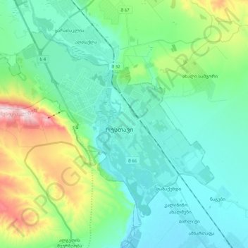
Name: Rustavi topographic map, elevation, terrain.
Location: Rustavi, Lower Kartli, 3700, Georgia (41.49106 44.89030 41.60117 45.08626)
Average elevation: 1,319 ft
Minimum elevation: 978 ft
Maximum elevation: 2,503 ft
Make a donation
Gear up for your next adventure:
As an Amazon Associate, this site earns from qualifying purchases at no extra cost to you.
Other topographic maps
Click on a map to view its topography, its elevation and its terrain.
Gardabani
Georgia > Lower Kartli > Gardabani Municipality
Gardabani (Georgian: გარდაბანი) is a city of 11,650 residents (2021) in the southern Georgian region of Kvemo Kartli and is the administrative centre of the Gardabani Municipality. It is located 34 kilometres (21 mi) southeast of capital Tbilisi and 10 kilometres (6.2 mi) from Rustavi in the…
Average elevation: 981 ft
Make a donation
Gear up for your next adventure:
As an Amazon Associate, this site earns from qualifying purchases at no extra cost to you.