
Sevry topographic map
Click on the map to display elevation.
About this map
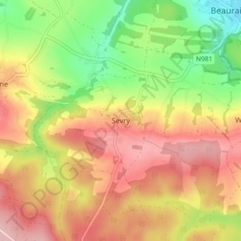
Name: Sevry topographic map, elevation, terrain.
Average elevation: 902 ft
Minimum elevation: 594 ft
Maximum elevation: 1,168 ft
Other topographic maps
Click on a map to view its topography, its elevation and its terrain.
Vresse-sur-Semois
Vresse-sur-Semois, située dans la province de Namur, en Wallonie, est un village ardennais situé à environ 180 mètres d'altitude, niché sur la rive droite de la sinueuse Semois, à sa confluence avec le ruisseau de Ruaumoulin. Le village est particulièrement marqué par son terrain accidenté, où la…
Average elevation: 1,076 ft
Falmagne
Belgique > Namur > Dinant > Dinant
Falmagne est situé au sud de la vallée de la Lesse (un affluent de la Meuse), à la limite entre les zones géologiques du Condroz et de la Famenne. À une altitude d'environ 230 m, il est situé sur un plateau et surplombe le village de Falmignoul.
Average elevation: 748 ft
Falaën
Falaën est un village du Condroz implanté sur un plateau dominant plusieurs vallées dont celle de la Molignée au nord et du Flavion à l'est. Le village, assez concentré, s'étend à la naissance d'un vallon. L'altitude à l'église est de 200 m. Le village reprend les quartiers de l'Ormont, les Bruyères…
Average elevation: 699 ft
Bioul
On y compte trois ruisseaux : au nord du village, le Burnot, affluent direct de la Meuse, à l'est le ruisseau d'Annevoie et la Fontaine du Wez-du-Mont au centre du village. La vallée du Burnot et celle de la vallée de la Meuse ont fortement entaillé le plateau condruzien. Le relief de Bioul est ainsi…
Average elevation: 705 ft
Furfooz
Belgique > Namur > Dinant > Dinant
Furfooz est aussi connu pour ses vestiges de la Préhistoire (découverts dans certaines de ses grottes) ainsi que de l'époque romaine. À ce jour, le parc de Furfooz permet la visite des restes d'un ancien camp romain dominant de quelque 100 m d'altitude la Lesse, sur un monticule surnommé la Haute-Racine.
Average elevation: 692 ft
Onhaye
Le village d'Onhaye est un bourg étendu et étiré le long d'un tige (altitude jusqu'à 260 m) et sur le versant peu incliné s'orientant vers le sud. Le village se rassemble autour de l'église et de quelques fermes importantes. Il a été édifié en pierre calcaire mais aussi en brique dès la fin du XVIII…
Average elevation: 656 ft
Lisogne
Belgique > Namur > Dinant > Dinant
À 6,5 km de Dinant, le village de Lisogne se situe sur un plateau dominant le versant nord du ruisseau des Fonds de Leffe et la rive droite de la vallée de la Meuse. Le relief de Lisogne est assez accidenté et fortement entaillé par le ruisseau des Fonds de Leffe. L'altitude varie entre 180 m et 295 m sur…
Average elevation: 807 ft
Houdremont
Le suffixe "-mont" de "Houdremont" pourrait venir soit de "mons" (le mont) précédé du nom, ce qui donnerait une origine comme "Hodradi mons" ou "Hulderici mons" (ou encore Holdrad ou Hulderic, Ulrich) ; soit de "mansio", la demeure, la maison, et donc signifier la "demeure de Holdrad" ou Hulderic". L'abbé…
Average elevation: 1,260 ft
Mont
Dominant la vallée de la Meuse, le village de Mont est étalé sur le versant le long de deux rues principales recoupées perpendiculairement par quelques voiries secondaires. Habitat composé de maisons en moellons de grès mêlés à du calcaire, parfois chaulés ; développement important de l’habitat à…
Average elevation: 748 ft