
Make a donation
Gear up for your next adventure:
As an Amazon Associate, this site earns from qualifying purchases at no extra cost to you.
Laforêt topographic map
Click on the map to display elevation.
Make a donation
Gear up for your next adventure:
As an Amazon Associate, this site earns from qualifying purchases at no extra cost to you.
About this map
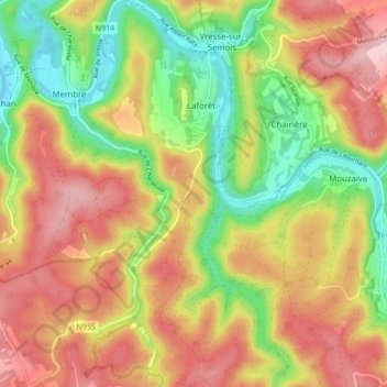
Name: Laforêt topographic map, elevation, terrain.
Location: Laforêt, Vresse-sur-Semois, Dinant, Namur, Wallonie, Belgique (49.82377 4.90477 49.87892 4.93886)
Average elevation: 958 ft
Minimum elevation: 551 ft
Maximum elevation: 1,348 ft
Make a donation
Gear up for your next adventure:
As an Amazon Associate, this site earns from qualifying purchases at no extra cost to you.
Other topographic maps
Click on a map to view its topography, its elevation and its terrain.
Make a donation
Gear up for your next adventure:
As an Amazon Associate, this site earns from qualifying purchases at no extra cost to you.
Make a donation
Gear up for your next adventure:
As an Amazon Associate, this site earns from qualifying purchases at no extra cost to you.
Croix Scaille
Belgique > Namur > Dinant > Gedinne
Point culminant du versant méridional du massif ardennais, avec 504 mètres d'altitude, il se trouve exactement à la frontière franco-belge, à la limite du département des Ardennes (commune des Hautes-Rivières), et de la province de Namur (commune de Gedinne).
Average elevation: 1,522 ft
Make a donation
Gear up for your next adventure:
As an Amazon Associate, this site earns from qualifying purchases at no extra cost to you.
Make a donation
Gear up for your next adventure:
As an Amazon Associate, this site earns from qualifying purchases at no extra cost to you.
Make a donation
Gear up for your next adventure:
As an Amazon Associate, this site earns from qualifying purchases at no extra cost to you.
Make a donation
Gear up for your next adventure:
As an Amazon Associate, this site earns from qualifying purchases at no extra cost to you.
Make a donation
Gear up for your next adventure:
As an Amazon Associate, this site earns from qualifying purchases at no extra cost to you.
Houdremont
Le suffixe "-mont" de "Houdremont" pourrait venir soit de "mons" (le mont) précédé du nom, ce qui donnerait une origine comme "Hodradi mons" ou "Hulderici mons" (ou encore Holdrad ou Hulderic, Ulrich) ; soit de "mansio", la demeure, la maison, et donc signifier la "demeure de Holdrad" ou Hulderic". L'abbé…
Average elevation: 1,273 ft
Make a donation
Gear up for your next adventure:
As an Amazon Associate, this site earns from qualifying purchases at no extra cost to you.
Make a donation
Gear up for your next adventure:
As an Amazon Associate, this site earns from qualifying purchases at no extra cost to you.
Make a donation
Gear up for your next adventure:
As an Amazon Associate, this site earns from qualifying purchases at no extra cost to you.
Make a donation
Gear up for your next adventure:
As an Amazon Associate, this site earns from qualifying purchases at no extra cost to you.
Make a donation
Gear up for your next adventure:
As an Amazon Associate, this site earns from qualifying purchases at no extra cost to you.
Make a donation
Gear up for your next adventure:
As an Amazon Associate, this site earns from qualifying purchases at no extra cost to you.
Make a donation
Gear up for your next adventure:
As an Amazon Associate, this site earns from qualifying purchases at no extra cost to you.
Make a donation
Gear up for your next adventure:
As an Amazon Associate, this site earns from qualifying purchases at no extra cost to you.
Mont
Dominant la vallée de la Meuse, le village de Mont est étalé sur le versant le long de deux rues principales recoupées perpendiculairement par quelques voiries secondaires. Habitat composé de maisons en moellons de grès mêlés à du calcaire, parfois chaulés; développement important de l’habitat à…
Average elevation: 666 ft
Make a donation
Gear up for your next adventure:
As an Amazon Associate, this site earns from qualifying purchases at no extra cost to you.
Make a donation
Gear up for your next adventure:
As an Amazon Associate, this site earns from qualifying purchases at no extra cost to you.
Make a donation
Gear up for your next adventure:
As an Amazon Associate, this site earns from qualifying purchases at no extra cost to you.
Make a donation
Gear up for your next adventure:
As an Amazon Associate, this site earns from qualifying purchases at no extra cost to you.
Make a donation
Gear up for your next adventure:
As an Amazon Associate, this site earns from qualifying purchases at no extra cost to you.
Make a donation
Gear up for your next adventure:
As an Amazon Associate, this site earns from qualifying purchases at no extra cost to you.
Make a donation
Gear up for your next adventure:
As an Amazon Associate, this site earns from qualifying purchases at no extra cost to you.
Croix Scaille
Belgique > Namur > Dinant > Gedinne
Point culminant du versant méridional du Massif ardennais, avec 504 mètres d'altitude, il se trouve exactement à la frontière franco-belge, à la limite du département des Ardennes (commune des Hautes-Rivières), et de la province de Namur (commune de Gedinne).
Average elevation: 1,522 ft
Make a donation
Gear up for your next adventure:
As an Amazon Associate, this site earns from qualifying purchases at no extra cost to you.