Geolocate

磁器口街道 topographic map

Interactive map

Click on the map to display elevation.

About this map

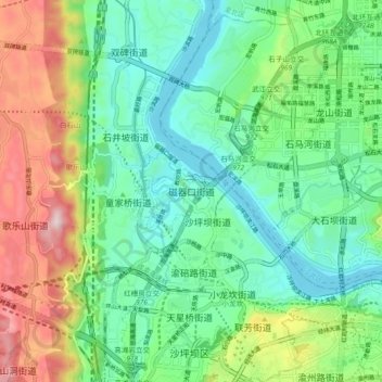
Name: 磁器口街道 topographic map, elevation, terrain.

Location: 磁器口街道, 沙坪坝区, 重庆市主城都市区, 重庆市, 400030, 中国 (29.53748 106.41403 29.61748 106.49403)

Average elevation: 1,014 ft

Minimum elevation: 518 ft

Maximum elevation: 2,103 ft

Other topographic maps

Click on a map to view its topography, its elevation and its terrain.

西永街道

中国 > 重庆市 > 沙坪坝区 > 永祥社区

西永街道, 重庆高新区, 永祥社区, 沙坪坝区, 重庆市, 中国

Average elevation: 1,214 ft

中梁镇

中国 > 重庆市 > 沙坪坝区

中梁镇, 沙坪坝区, 重庆市, 中国

Average elevation: 1,148 ft

崇贤社区

中国 > 重庆市 > 沙坪坝区

崇贤社区, 沙坪坝区, 重庆市, 401331, 中国

Average elevation: 958 ft

天马山社区

中国 > 重庆市 > 沙坪坝区

天马山社区, 沙坪坝区, 重庆市, 401331, 中国

Average elevation: 958 ft

永祥社区

中国 > 重庆市 > 沙坪坝区

永祥社区, 沙坪坝区, 重庆市, 中国

Average elevation: 961 ft

双碑街道

中国 > 重庆市 > 沙坪坝区

双碑街道, 沙坪坝区, 重庆市, 400030, 中国

Average elevation: 1,083 ft

虎溪街道

中国 > 重庆市 > 沙坪坝区

虎溪街道, 重庆高新区, 沙坪坝区, 重庆市, 401331, 中国

Average elevation: 1,168 ft