Geolocate

Paita topographic map

Click on the map to display elevation.

About this map

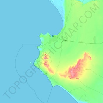
Name: Paita topographic map, elevation, terrain.

Location: Paita, Province of Paita, Piura, Peru (-5.38846 -81.19581 -4.92450 -80.96101)

Average elevation: 151 ft

Minimum elevation: -7 ft

Maximum elevation: 1,155 ft

Other topographic maps

Click on a map to view its topography, its elevation and its terrain.

San Pablo

Peru > Piura > Pacaipampa > Lagunas De San Pablo

Average elevation: 7,005 ft

Tambogrande

Peru > Piura > Tambo Grande

Average elevation: 240 ft

Vichayito

Peru > Piura > Los Órganos

Average elevation: 56 ft

San Pablo

Peru > Piura > Pacaipampa > Lagunas De San Pablo

Average elevation: 7,005 ft

Locuto

Peru > Piura > Tambo Grande

Average elevation: 236 ft

Locuto

Peru > Piura > Tambo Grande

Average elevation: 236 ft

Jilili

Peru > Piura > Jililí

Average elevation: 5,121 ft

Sapalache

Peru > Piura > El Carmen de la Frontera

Average elevation: 8,130 ft

Sicchez

Peru > Piura > Sícchez

Average elevation: 5,135 ft

El Salto

Peru > Piura > Tambo Grande

Average elevation: 240 ft

Mejia

Peru > Piura > Sullana

Average elevation: 253 ft

Qf

Peru > Piura > 26 de Octubre

Average elevation: 135 ft

Fb

Peru > Piura > 26 de Octubre

Average elevation: 131 ft

Sicchez

Peru > Piura > Sícchez

Average elevation: 5,135 ft

Pico de Loro

Peru > Piura > Jililí

Average elevation: 3,894 ft

Frias

Peru > Piura > Frías

Average elevation: 6,056 ft

Las Vegas

Peru > Piura > Sícchez

Average elevation: 4,173 ft

Lobitos

Peru > Piura

Average elevation: 43 ft

Nuevo Pozo Oscuro

Peru > Piura > Cristo nos Valga

Average elevation: 72 ft

Pico de Loro

Peru > Piura > Jililí

Average elevation: 3,894 ft

Narihualá

Peru > Piura > Catacaos

Average elevation: 72 ft

Chira

Peru > Piura > Sullana

Average elevation: 164 ft

Mancora

Peru > Piura > Máncora

Average elevation: 72 ft

Talara

Peru > Piura > Pariñas

Average elevation: 138 ft

Pico de Loro

Peru > Piura > Jililí

Average elevation: 3,894 ft

Gear up for your next adventure:

🗺️NatGeo Topo Maps - High-quality waterproof printed topographic maps of US Parks
🧭Compass with Lanyard - Easy‑carry compass for navigation
🛌Ultralight Sleeping Bags - Compact down bags for cold nights in the wilderness
🌡️Portable Weather Meter - Track weather conditions on the trail
🔭Compact Binoculars - HD vision for scouting terrain and identifying distant landmarks

As an Amazon Associate, this site earns from qualifying purchases at no extra cost to you.