
Make a donation
Gear up for your next adventure:
As an Amazon Associate, this site earns from qualifying purchases at no extra cost to you.
Landkreis Merzig-Wadern topographic map
Click on the map to display elevation.
Make a donation
Gear up for your next adventure:
As an Amazon Associate, this site earns from qualifying purchases at no extra cost to you.
About this map
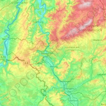
Name: Landkreis Merzig-Wadern topographic map, elevation, terrain.
Location: Landkreis Merzig-Wadern, Saarland, Deutschland (49.37213 6.35760 49.61303 6.96296)
Average elevation: 1,027 ft
Minimum elevation: 430 ft
Maximum elevation: 2,343 ft
Make a donation
Gear up for your next adventure:
As an Amazon Associate, this site earns from qualifying purchases at no extra cost to you.
Other topographic maps
Click on a map to view its topography, its elevation and its terrain.
Bostalsee
Deutschland > Saarland > Landkreis St. Wendel > Nohfelden
Wegen der Bauwerkshöhe des Sperrdamms von mehr als fünf Metern über Talgrund gilt der Bostalsee juristisch und technisch als Talsperre und wird entsprechend durch die Erlaubnisbehören überwacht. Gemäß der Nomenklatur müsste sie als Bosbachtalsperre oder Talsperre Bosen bezeichnet werden.
Average elevation: 1,352 ft
Biosphärenreservat Bliesgau
Bestimmend für das Klima im Bliesgau sind unterschiedliche Großwetterlagen. Herrscht bei westlichen Großwetterlagen eine milde und feuchte Witterung vor, so ist es bei östlichen Lagen trocken und im Sommer heiß, im Winter kalt. Aus dem Süden kommt eine warme bis heiße Witterung mit unterschiedlichen…
Average elevation: 1,017 ft
Südlicher Bliesgau/Auf der Lohe
Deutschland > Saarland > Saarpfalz-Kreis > Gersheim
Das rund 1575 ha große Gebiet wurde mit Verordnung vom 26. März 2004 unter der Kenn-Nummer NSG-108 unter Naturschutz gestellt. Es umfasst Hangflächen und Höhenzüge westlich der Blies.
Average elevation: 984 ft
Tiefenbachklamm
Deutschland > Saarland > Regionalverband Saarbrücken > Kleinblittersdorf
Average elevation: 886 ft
Make a donation
Gear up for your next adventure:
As an Amazon Associate, this site earns from qualifying purchases at no extra cost to you.
St. Nikolaus Weiher
Deutschland > Saarland > Regionalverband Saarbrücken > Großrosseln
Average elevation: 833 ft
Make a donation
Gear up for your next adventure:
As an Amazon Associate, this site earns from qualifying purchases at no extra cost to you.
Landsweiler-Reden
Deutschland > Saarland > Landkreis Neunkirchen > Schiffweiler
Average elevation: 997 ft
Make a donation
Gear up for your next adventure:
As an Amazon Associate, this site earns from qualifying purchases at no extra cost to you.
Heiligenwald
Deutschland > Saarland > Landkreis Neunkirchen > Schiffweiler
In Schiffweiler wurde 2014 ein Windpark errichtet. Der Park besteht aus fünf identischen Windkraftanlagen des Typs Vensys112. Die Nabenhöhe der Anlagen beträgt 140 Meter, der Rotordurchmesser beträgt 112 Meter, was einer Rotorkreisfläche von ca. 1 ha und einer Gesamthöhe von ca. 196 Meter entspricht. Die…
Average elevation: 1,056 ft
Make a donation
Gear up for your next adventure:
As an Amazon Associate, this site earns from qualifying purchases at no extra cost to you.
Litermont
Deutschland > Saarland > Landkreis Saarlouis > Nalbach
Der im Saarland gelegene Litermont ist ein Höhenzug von bis zu 414,2 m ü. NHN und erstreckt sich größtenteils in das Nalbacher Tal, mit kleineren Ausläufern bis nach Düppenweiler.
Average elevation: 1,004 ft
Nagelsberg
Deutschland > Saarland > Regionalverband Saarbrücken > Heusweiler
Average elevation: 827 ft
Make a donation
Gear up for your next adventure:
As an Amazon Associate, this site earns from qualifying purchases at no extra cost to you.
Make a donation
Gear up for your next adventure:
As an Amazon Associate, this site earns from qualifying purchases at no extra cost to you.
Stausee Losheim
Deutschland > Saarland > Landkreis Merzig-Wadern > Losheim am See
Average elevation: 1,086 ft
Königsbruch / Jägersburger Wald
Deutschland > Saarland > Saarpfalz-Kreis > Homburg
Average elevation: 843 ft
Make a donation
Gear up for your next adventure:
As an Amazon Associate, this site earns from qualifying purchases at no extra cost to you.
Staffelberg
Deutschland > Saarland > Regionalverband Saarbrücken > Saarbrücken
Average elevation: 1,086 ft
Make a donation
Gear up for your next adventure:
As an Amazon Associate, this site earns from qualifying purchases at no extra cost to you.
Bierbach
Deutschland > Saarland > Saarpfalz-Kreis > Blieskastel
Der Gollenstein wurde vor 4000 Jahren errichtet. Er gilt als der größte Menhir Mitteleuropas und als eines der ältesten Kulturdenkmäler in Deutschland. Zwölf Grabhügel an der Straße von Böckweiler nach Mimbach stammen aus der Hallstattzeit. Auf dem Höhenrücken zwischen Wolfersheim und Rubenheim…
Average elevation: 902 ft
Großer Homburg
Deutschland > Saarland > Regionalverband Saarbrücken > Saarbrücken
Average elevation: 850 ft
Make a donation
Gear up for your next adventure:
As an Amazon Associate, this site earns from qualifying purchases at no extra cost to you.
Schwarzenbach-Ziegelhütte
Deutschland > Saarland > Landkreis St. Wendel > Nonnweiler
Average elevation: 1,539 ft
Make a donation
Gear up for your next adventure:
As an Amazon Associate, this site earns from qualifying purchases at no extra cost to you.
Naturschutzgebiet Wadrilltal
Deutschland > Saarland > Landkreis Merzig-Wadern > Wadern
Average elevation: 1,060 ft
Fallenseifenberg
Deutschland > Saarland > Landkreis Merzig-Wadern > Wadern
Average elevation: 1,539 ft
Make a donation
Gear up for your next adventure:
As an Amazon Associate, this site earns from qualifying purchases at no extra cost to you.
Schwarzenbach
Deutschland > Saarland > Saarpfalz-Kreis > Homburg
Das im Osten des Saarlandes gelegene Homburg grenzt an die Ausläufer des Pfälzerwaldes. Die westlichen Stadtteile Beeden, Schwarzenbach, Wörschweiler, Schwarzenacker, Einöd und Ingweiler liegen im bzw. am Tal der Blies. Der teilweise verwendete Namenszusatz „(Saar)“ (auch „/Saar“) ist ein Relikt…
Average elevation: 879 ft
Make a donation
Gear up for your next adventure:
As an Amazon Associate, this site earns from qualifying purchases at no extra cost to you.
Reidelbach
Deutschland > Saarland > Landkreis Merzig-Wadern > Wadern > Wedern
Average elevation: 1,296 ft
Make a donation
Gear up for your next adventure:
As an Amazon Associate, this site earns from qualifying purchases at no extra cost to you.
Make a donation
Gear up for your next adventure:
As an Amazon Associate, this site earns from qualifying purchases at no extra cost to you.
Schimmelkopf
Deutschland > Saarland > Landkreis Merzig-Wadern > Weiskirchen
Average elevation: 1,985 ft
Schaumberg
Deutschland > Saarland > Landkreis St. Wendel > Tholey
Der Schaumberg ist ein Berg im Saarland und die höchste Erhebung im Naturraum Prims-Blies-Hügelland. Der Berg ist ein Kegelberg vulkanischen Ursprungs. Mit einer Höhe von 568,2 m und dem aufgesetzten markanten Schaumbergturm ist er aus weiter Entfernung sichtbar und gilt als „Hausberg des Saarlandes“,…
Average elevation: 1,329 ft
Make a donation
Gear up for your next adventure:
As an Amazon Associate, this site earns from qualifying purchases at no extra cost to you.
Feriendorf Mitlosheim
Deutschland > Saarland > Losheim am See > Feriendorf Mitlosheim
Average elevation: 1,306 ft
Make a donation
Gear up for your next adventure:
As an Amazon Associate, this site earns from qualifying purchases at no extra cost to you.
Scheiden
Deutschland > Saarland > Landkreis Merzig-Wadern > Losheim am See > Scheiden
Average elevation: 1,552 ft
Make a donation
Gear up for your next adventure:
As an Amazon Associate, this site earns from qualifying purchases at no extra cost to you.
Stennweiler
Deutschland > Saarland > Landkreis Neunkirchen > Schiffweiler > Stennweiler
Average elevation: 1,122 ft
Neu-Aschbach
Deutschland > Saarland > Regionalverband Saarbrücken > Saarbrücken
Average elevation: 764 ft
Rissenthal
Deutschland > Saarland > Landkreis Merzig-Wadern > Losheim am See > Rissenthal
Average elevation: 1,001 ft
Pfaffenkopf
Deutschland > Saarland > Regionalverband Saarbrücken > Saarbrücken
Average elevation: 965 ft
Make a donation
Gear up for your next adventure:
As an Amazon Associate, this site earns from qualifying purchases at no extra cost to you.
Göttelborn
Deutschland > Saarland > Regionalverband Saarbrücken > Göttelborn
Average elevation: 1,155 ft
Pillinger Hof
Deutschland > Saarland > Landkreis Merzig-Wadern > Perl > Borg
Average elevation: 1,040 ft
Make a donation
Gear up for your next adventure:
As an Amazon Associate, this site earns from qualifying purchases at no extra cost to you.
Schwarzenbach
Deutschland > Saarland > Saarpfalz-Kreis > Homburg
Das im Osten des Saarlandes gelegene Homburg grenzt an die Ausläufer des Pfälzerwaldes. Die westlichen Stadtteile Beeden, Schwarzenbach, Wörschweiler, Schwarzenacker, Einöd und Ingweiler liegen im bzw. am Tal der Blies. Der teilweise verwendete Namenszusatz „(Saar)“ (auch „/Saar“) ist ein Relikt…
Average elevation: 879 ft