
Surquillo topographic map
Click on the map to display elevation.
Surquillo
Since the beginning of the 2000s and the beginning of the 2010s, and to a greater extent today, there has been a considerable real estate boom within Surquillo, in which many residential real estate companies have invested in new residential building projects in several points of the district due to the modification of the urban and building parameters in the district. For this reason, many high-altitude residential buildings have been built in different points such as the areas adjacent to Principal and Andrés Aramburú avenues, as well as parts of urbanizations such as La Calera, Barrio Médico, Los Sauces, and recently along the route of Tomás Marsano Avenue on the border with the Miraflores district and sections of Angamos Avenue. This also brought about the appreciation of house prices in various parts of the district.
About this map
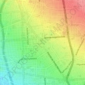
Name: Surquillo topographic map, elevation, terrain.
Average elevation: 394 ft
Minimum elevation: 256 ft
Maximum elevation: 535 ft
Other topographic maps
Click on a map to view its topography, its elevation and its terrain.
Lima
The suburban district of Cieneguilla, the district of Pachacámac and the district of Chosica provide important tourist attractions among locals. Due to its elevation (over 500 masl), the sun shines in Chosica during the winter, being very visited by the residents of Lima to escape the urban fog.
Average elevation: 774 ft
Lima
The suburban district of Cieneguilla, the district of Pachacámac and the district of Chosica provide important tourist attractions among locals. Due to its elevation (over 500 masl), the sun shines in Chosica during the winter, being very visited by the residents of Lima to escape the urban fog.
Average elevation: 663 ft
Morro Solar
Peru > Lima > Chorrillos
Morro Solar, a cluster of hills, is roughly 251 metres (823 ft) in elevation. It lies near Chorrillos, a southern suburb of Lima, occupying an area of 7.48 square kilometres (2.89 sq mi). Alexander George Findlay described it as "a remarkable cluster of hills, standing on a sandy plain; when seen from the…
Average elevation: 125 ft
Lima
The suburban district of Cieneguilla, the district of Pachacámac and the district of Chosica provide important tourist attractions among locals. Due to its elevation (over 500 masl), the sun shines in Chosica during the winter, being very visited by the residents of Lima to escape the urban fog.
Average elevation: 774 ft
Lima
The suburban district of Cieneguilla, the district of Pachacámac and the district of Chosica provide important tourist attractions among locals. Due to its elevation (over 500 masl), the sun shines in Chosica during the winter, being very visited by the residents of Lima to escape the urban fog.
Average elevation: 663 ft
Lima
The suburban district of Cieneguilla, the district of Pachacámac and the district of Chosica provide important tourist attractions among locals. Due to its elevation (over 500 masl), the sun shines in Chosica during the winter, being very visited by the residents of Lima to escape the urban fog.
Average elevation: 774 ft