Geolocate

Bolckow topographic map

Click on the map to display elevation.

About this map

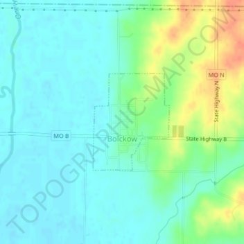
Name: Bolckow topographic map, elevation, terrain.

Location: Bolckow, Andrew County, Missouri, United States (40.10951 -94.82643 40.12028 -94.81537)

Average elevation: 958 ft

Minimum elevation: 915 ft

Maximum elevation: 1,060 ft

Andrew County trails, hiking, mountain biking, running and outdoor activities

Other topographic maps

Click on a map to view its topography, its elevation and its terrain.

Empire Prairie

United States > Missouri > Andrew County

Average elevation: 1,076 ft

Riggin Branch

United States > Missouri > Andrew County

Average elevation: 945 ft

Avenue City

United States > Missouri > Andrew County

Average elevation: 925 ft

Flag Springs

United States > Missouri > Andrew County

Average elevation: 1,030 ft

Fountainbleau

United States > Missouri > Andrew County

Average elevation: 981 ft

Kodiak

United States > Missouri > Andrew County

Average elevation: 994 ft

Nodaway

United States > Missouri > Andrew County

Average elevation: 892 ft

Rankin

United States > Missouri > Andrew County

Average elevation: 988 ft

Rochester

United States > Missouri > Andrew County

Average elevation: 945 ft

Whitesville

United States > Missouri > Andrew County

Average elevation: 961 ft

Wyeth

United States > Missouri > Andrew County

Average elevation: 958 ft

Gear up for your next adventure:

🩳Quick‑Dry Hiking Shorts - Comfortable and quick‑dry shorts for summer hiking
😴Insulated Sleeping Pads - Compact and warm pads for high-elevation camping
🌎3D Topographic Globes - Raised relief globes for a tactile understanding of geography
🌡️Portable Weather Meter - Track weather conditions on the trail
🔋Solar Power Banks - Keep your GPS and phone charged in remote wilderness areas

As an Amazon Associate, this site earns from qualifying purchases at no extra cost to you.