Geolocate

Pangil topographic map

Click on the map to display elevation.

Pangil

The municipality is strategically situated at the southern tip of Sierra Madre mountain range (six barangays) and along the eastern margin of Jalajala Peninsula and just west of the northwestern shore of the easternmost major embayment of Laguna de Bay (two barangays). Its narrow strip of territory traverses in its length by Pangil River (12.5 km long), valued for its pristine and abundant water contributing to its domestic, agricultural, ecotourism and other potential economic uses like bulk water and hydropower. Its topography is generally flat in between rolling and steep hills.

Wikipedia (CC-BY-SA 3.0)

About this map

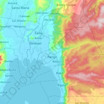
Name: Pangil topographic map, elevation, terrain.

Location: Pangil, Laguna, Calabarzon, 4018, Philippines (14.36277 121.39184 14.45636 121.53830)

Average elevation: 538 ft

Minimum elevation: -16 ft

Maximum elevation: 1,831 ft

Other topographic maps

Click on a map to view its topography, its elevation and its terrain.

Cabuyao

Philippines > Laguna > Cabuyao

Average elevation: 305 ft

Jose Rizal

Philippines > Laguna > Santa Maria

Average elevation: 82 ft

Bumbungan Overflow

Philippines > Laguna > Cavinti > Duhat

Average elevation: 735 ft

Natividad

Philippines > Laguna > Pangil

Average elevation: 230 ft

Canlubang

Philippines > Laguna > Canlubang

Average elevation: 525 ft

Pila

Philippines > Laguna > Pila

Average elevation: 36 ft

Sitio Maharlika

Philippines > Laguna > San Pedro

Average elevation: 89 ft

Aliw Falls

Philippines > Laguna > Luisiana > San Salvador

Average elevation: 1,079 ft

San Jose

Philippines > Laguna > Luisiana

Average elevation: 1,227 ft

Bay River

Philippines > Laguna > Bay

Average elevation: 20 ft

Botocan

Philippines > Laguna > Majayjay

Average elevation: 1,125 ft

La Mesa

Philippines > Laguna > Calamba

Average elevation: 787 ft

Bay River

Philippines > Laguna > Bay

Average elevation: 16 ft

San Antonio

Philippines > Laguna > Kalayaan

Average elevation: 1,053 ft

88 Spa & Resort

Philippines > Laguna > Calamba

Average elevation: 272 ft

Kayhakat

Philippines > Laguna > Santa Maria

Average elevation: 89 ft

Balatuin River

Philippines > Laguna > San Pablo > San Miguel

Average elevation: 243 ft

Ibaba del Sur

Philippines > Laguna > Paete > Ibaba del Sur

Average elevation: 272 ft

Numero

Philippines > Laguna > Mabitac > Numero

Average elevation: 295 ft

Siniloan River

Philippines > Laguna > Siniloan > Siniloan

Average elevation: 26 ft

Balayhangin

Philippines > Laguna > Calauan > Balayhangin

Average elevation: 285 ft

Mount San Cristobal

Philippines > Laguna > Nagcarlan

Average elevation: 2,913 ft

San Juan River

Philippines > Laguna > Calamba

Average elevation: 30 ft

Ilaya Palina

Philippines > Laguna > Nagcarlan > Ilaya Palina

Average elevation: 728 ft

Dorado

Philippines > Laguna

Average elevation: 869 ft

Mount Makiling

Philippines > Laguna > Los Baños

Average elevation: 1,073 ft

Gear up for your next adventure:

🖼️Topo Map Wall Art - Decorative topographic prints of famous peaks and regions
🪶Compact Camp Shovel - Folding shovel for campsite tasks
🧤Tactile Hiking Gloves - Keep hands warm while operating GPS and smartphone screens
🗺️Topographic Maps - Detailed topo maps for hiking, exploring and outdoor navigation
🧥Waterproof Jacket for Hiking - Breathable and rugged rain jacket for outdoor excursions

As an Amazon Associate, this site earns from qualifying purchases at no extra cost to you.