
Chari-Baguirmi topographic map
Interactive map
Click on the map to display elevation.
About this map
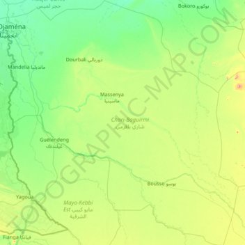
Name: Chari-Baguirmi topographic map, elevation, terrain.
Location: Chari-Baguirmi, Chad (9.82600 15.02620 12.43200 17.54300)
Average elevation: 1,063 ft
Minimum elevation: 938 ft
Maximum elevation: 1,818 ft
Other topographic maps
Click on a map to view its topography, its elevation and its terrain.
Djamena
Chad > Chari-Baguirmi > Mandelia
Djamena, Mandelia, Chari-Baguirmi, Chad
Average elevation: 984 ft
Kabia
Chad > Mayo-Kebbi Est > Gounou Gaya
Kabia, Gounou Gaya, Mayo-Kebbi Est, Chad
Average elevation: 1,145 ft
Iro بحيرة إيرو
Chad > Moyen-Chari > Campement Pêcheur Borno
Iro بحيرة إيرو, Campement Pêcheur Borno, Moyen-Chari, Chad
Average elevation: 1,273 ft