Geolocate

Guangopolo topographic map

Click on the map to display elevation.

About this map

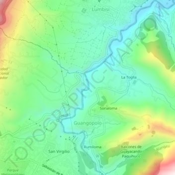
Name: Guangopolo topographic map, elevation, terrain.

Location: Guangopolo, Quito Canton, Pichincha, Ecuador (-0.27069 -78.45796 -0.22998 -78.41825)

Average elevation: 8,189 ft

Minimum elevation: 7,539 ft

Maximum elevation: 9,695 ft

Other topographic maps

Click on a map to view its topography, its elevation and its terrain.

Marianitas

Ecuador > Pichincha > Quito Canton > Nanegal

Average elevation: 4,390 ft

Calderón

Ecuador > Pichincha > Quito Canton

Average elevation: 8,340 ft

Pululahua

Ecuador > Pichincha > Quito Canton > Calacali

Average elevation: 9,035 ft

Santa Rosa

Ecuador > Pichincha > Quito Canton > Puembo

Average elevation: 7,900 ft

Tanlahua

Ecuador > Pichincha > Quito Canton > San Antonio

Average elevation: 8,520 ft

Frutillas

Ecuador > Pichincha > Quito Canton > Nono

Average elevation: 9,767 ft

La Concepcion

Ecuador > Pichincha > Quito Canton > Guayllabamba

Average elevation: 7,090 ft

Ilaló

Ecuador > Pichincha > Quito Canton > Tumbaco

Average elevation: 9,629 ft

Alaspungo

Ecuador > Pichincha > Quito Canton > Nono > Alaspungo

Average elevation: 9,039 ft

Carapungo

Ecuador > Pichincha > Quito Canton > Carapungo

Average elevation: 8,839 ft

Tandayapa

Ecuador > Pichincha > Quito Canton

Average elevation: 6,467 ft

Cachillacta

Ecuador > Pichincha > Quito Canton > Nanegal > Cachillacta

Average elevation: 4,514 ft

Zámbiza

Ecuador > Pichincha > Quito Canton

Average elevation: 8,625 ft

Gear up for your next adventure:

🌡️Handheld Weather Meters - Measure wind, temp, and pressure for safe mountain travel
🎒Day Hiking Backpack - Lightweight backpack perfect for day trips and outdoor adventures
🪶Wildlife Field Guides - Learn animal tracking and species ID
🛰️Satellite Messengers - Emergency SOS and two-way messaging for off-grid adventures
📶Satellite Messenger - Communication device off‑grid

As an Amazon Associate, this site earns from qualifying purchases at no extra cost to you.