
Branson topographic map
Click on the map to display elevation.
Branson
Branson features a diverse and picturesque topography characterized by rolling hills, deep valleys, and abundant water features. Nestled in the Ozark Mountains, the area has an elevation that typically ranges around 778 feet (237 meters) above sea level. The region is shaped by its proximity to several lakes, including Table Rock Lake and Lake Taneycomo, which enhance the landscape's appeal with scenic shorelines and recreational opportunities. The rugged terrain, marked by limestone cliffs and dense woodlands, provides a backdrop for outdoor activities such as hiking, boating, and fishing, attracting both tourists and nature enthusiasts.
About this map
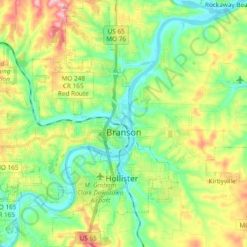
Name: Branson topographic map, elevation, terrain.
Location: Branson, Taney County, Missouri, United States (36.59433 -93.31472 36.70091 -93.21135)
Average elevation: 902 ft
Minimum elevation: 689 ft
Maximum elevation: 1,296 ft
Taney County trails, hiking, mountain biking, running and outdoor activities
Other topographic maps
Click on a map to view its topography, its elevation and its terrain.
Silver Dollar City's WhiteWater
United States > Missouri > Taney County > Branson
Average elevation: 971 ft