
Uttarakhand topographic map
Interactive map
Click on the map to display elevation.
About this map
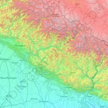
Name: Uttarakhand topographic map, elevation, terrain.
Location: Uttarakhand, India (28.72432 77.57133 31.45902 81.03086)
Average elevation: 6,913 ft
Minimum elevation: 525 ft
Maximum elevation: 25,121 ft
Uttarakhand lies on the southern slope of the Himalaya range, and the climate and vegetation vary greatly with elevation, from glaciers at the highest elevations to subtropical forests at the lower elevations. The highest elevations are covered by ice and bare rock. Below them, between 3,000 and 5,000 metres (9,800 and 16,400 ft) are the western Himalayan alpine shrub and meadows. The temperate western Himalayan subalpine conifer forests grow just below the tree line. At 3,000 to 2,600 metres (9,800 to 8,500 ft) elevation they transition to the temperate western Himalayan broadleaf forests, which lie in a belt from 2,600 to 1,500 metres (8,500 to 4,900 ft) elevation. Below 1,500 metres (4,900 ft) elevation lie the Himalayan subtropical pine forests. The Upper Gangetic Plains moist deciduous forests and the drier Terai-Duar savanna and grasslands cover the lowlands along the Uttar Pradesh border in a belt locally known as Bhabar. These lowland forests have mostly been cleared for agriculture, but a few pockets remain.
Other topographic maps
Click on a map to view its topography, its elevation and its terrain.
Sheoganj
India > Rajasthan > Sheoganj Tehsil
Sheoganj, Sheoganj Tehsil, Sirohi District, Rajasthan, 306902, India
Average elevation: 889 ft
Pokaran
India > Rajasthan > Pokaran Tehsil
Pokaran, Pokaran Tehsil, Jaisalmer District, Rajasthan, India
Average elevation: 751 ft
Awantipora
Awantipora, Pulwama District, Jammu and Kashmir, India
Average elevation: 5,463 ft
Delwara
India > Madhya Pradesh > Tyonda Tahsil
Delwara, Tyonda Tahsil, Vidisha District, Madhya Pradesh, India
Average elevation: 1,398 ft
Kuther
India > Jammu and Kashmir > Shangus tehsil
Kuther, Shangus tehsil, Anantnag District, Jammu and Kashmir, 192201, India
Average elevation: 6,109 ft
Singahalli
India > Karnataka > Kolar taluk
Singahalli, Kolar taluk, Kolar District, Karnataka, India
Average elevation: 2,799 ft
3d
India > Rajasthan > Ganganagar Tehsil > 1 LNP
3d, 1 LNP, Ganganagar Tehsil, Sri Ganganagar District, Rajasthan, India
Average elevation: 584 ft
Elimukku
India > Kerala > Kozhencherry
Elimukku, Kozhencherry, Pathanamthitta District, Kerala, 689504, India
Average elevation: 95 ft
Rohru
Rohru, Shimla District, Himachal Pradesh, 171207, India
Average elevation: 7,474 ft
Tral
Tral, Pulwama District, Jammu and Kashmir, 192123, India
Average elevation: 8,294 ft
Panner Jageer
India > Jammu and Kashmir > Tral
Panner Jageer, Tral, Pulwama District, Jammu and Kashmir, India
Average elevation: 6,631 ft
Malappuram
Malappuram, Ernad, Malappuram District, Kerala, India
Average elevation: 184 ft
Taiba
India > Jharkhand > Erki(Tamar II)
Taiba, Erki(Tamar II), Khunti District, Jharkhand, India
Average elevation: 1,850 ft
Surat
India > Gujarat > Katargam Taluka
Surat, Katargam Taluka, Surat District, Gujarat, 395008, India
Average elevation: 43 ft
Ameenpur mandal
Ameenpur mandal, Sangareddy District, Telangana, India
Average elevation: 1,811 ft
Sreekandapuram
India > Kerala > Taliparamba
Sreekandapuram, Taliparamba, Kannur District, Kerala, 670631, India
Average elevation: 230 ft
Kulana
India > Punjab > Budhlada Tahsil
Kulana, Budhlada Tahsil, Mansa District, Punjab, India
Average elevation: 725 ft
Hukkeri
India > Karnataka > Hukkeri taluk
Hukkeri, Hukkeri taluk, Karnataka, 591309, India
Average elevation: 2,162 ft
Patauda
India > Madhya Pradesh > Unchahara Tahsil
Patauda, Unchahara Tahsil, Satna District, Madhya Pradesh, India
Average elevation: 1,106 ft
Sector 37D
India > Haryana > Gurugram District
Sector 37D, Gurgaon, Gurugram District, Haryana, India
Average elevation: 712 ft
Nakrekal
India > Telangana > Nakrekal mandal
Nakrekal, Nakrekal mandal, Nalgonda District, Telangana, 508211, India
Average elevation: 679 ft
Manjavadi
India > Tamil Nadu > Kilvelur > Anaimangalam
Manjavadi, Anaimangalam, Kilvelur, Nagapattinam District, Tamil Nadu, 611104, India
Average elevation: 16 ft
Lal Kuan
India > Uttar Pradesh > Ghaziabad
Lal Kuan, Ghaziabad, Ghaziabad District, Uttar Pradesh, 201016, India
Average elevation: 692 ft
Chandupatla
India > Telangana > Maddirala mandal
Chandupatla, Maddirala mandal, Suryapet District, Telangana, India
Average elevation: 633 ft
Sengipatti
India > Tamil Nadu > Thanjavur
Sengipatti, Thanjavur, Thanjavur District, Tamil Nadu, India
Average elevation: 259 ft
Dehradun
India > Uttarakhand > Dehradun
Dehradun, Dehradun District, Uttarakhand, 248001, India
Average elevation: 2,966 ft
Ramchandrapuram
India > Andhra Pradesh > A.Konduru
Ramchandrapuram, A.Konduru, NTR, Andhra Pradesh, India
Average elevation: 322 ft
Simandhar Tenements & Flats
India > Gujarat > Mahesana Taluka
Simandhar Tenements & Flats, Mahesana Taluka, Mahesana District, Gujarat, 384001, India
Average elevation: 285 ft
Kadungalloor
India > Kerala > Paravur > Edayar
Kadungalloor, Edayar, Paravur, Ernakulam District, Kerala, India
Average elevation: 26 ft
Shast
India > Himachal Pradesh > Kotkhai
Shast, Kotkhai, Shimla District, Himachal Pradesh, 171204, India
Average elevation: 7,516 ft
Haraluru
India > Karnataka > Tumkur taluk
Haraluru, Tumkur taluk, Tumakuru District, Karnataka, India
Average elevation: 2,835 ft
Shivpuri District
Shivpuri District, Madhya Pradesh, India
Average elevation: 1,184 ft
Duldula
India > Chhattisgarh > Duldula Tahsil
Duldula, Duldula Tahsil, Jashpur District, Chhattisgarh, 496334, India
Average elevation: 1,739 ft
Jodhpur
India > Rajasthan > Jodhpur Tehsil
Jodhpur, Jodhpur Tehsil, Jodhpur District, Rajasthan, India
Average elevation: 781 ft
Boroonda
India > Rajasthan > Pipar City Tehsil
Boroonda, Pipar City Tehsil, Jodhpur(Rural) District, Rajasthan, India
Average elevation: 1,004 ft
Gubbalala
India > Karnataka > Bangalore South
Gubbalala, Bangalore South, Bengaluru Urban, Karnataka, 560062, India
Average elevation: 2,871 ft
Gairan Wasti
India > Maharashtra > Dharashiv > Waruda
Gairan Wasti, Waruda, Dharashiv, Dharashiv District, Maharashtra, India
Average elevation: 2,175 ft
Indian subcontinent
India > Maharashtra > Arni
Indian subcontinent, Arni, Yavatmal, Maharashtra, India
Average elevation: 1,155 ft
Shadnagar
India > Telangana > Farooqnagar mandal
Shadnagar, Farooqnagar mandal, Ranga Reddy District, Telangana, 509216, India
Average elevation: 2,073 ft
Tamluk
Tamluk, Purba Medinipur District, West Bengal, India
Average elevation: 13 ft
Digdoh
India > Maharashtra > Nagpur Urban Taluka
Digdoh, Nagpur Urban Taluka, Nagpur District, Maharashtra, 440019, India
Average elevation: 1,070 ft