
Harvester topographic map
Click on the map to display elevation.
About this map
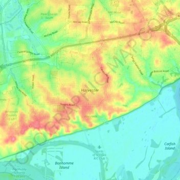
Name: Harvester topographic map, elevation, terrain.
Average elevation: 528 ft
Minimum elevation: 430 ft
Maximum elevation: 676 ft
Saint Charles County trails, hiking, mountain biking, running and outdoor activities
Other topographic maps
Click on a map to view its topography, its elevation and its terrain.
O’Fallon
United States > Missouri > Saint Charles County
O’Fallon is situated on gently rolling terrain that characterizes much of the St. Charles County landscape. The area features elevations ranging from about 400 to 600 feet above sea level, with the land gradually rising as it moves away from the Missouri River to the east. The city is interspersed with a mix…
Average elevation: 525 ft